
Tera Pass is a climb of 34.6 kilometers (hors catégorie). Tera Pass tops out at 2,890 m above sea level. It is located in پل علم ښار, لوگر ولايت, افغانستان. The average gradient is 3.2% with a maximum of 13.4%. The climb has 1118 meters of elevation gain.
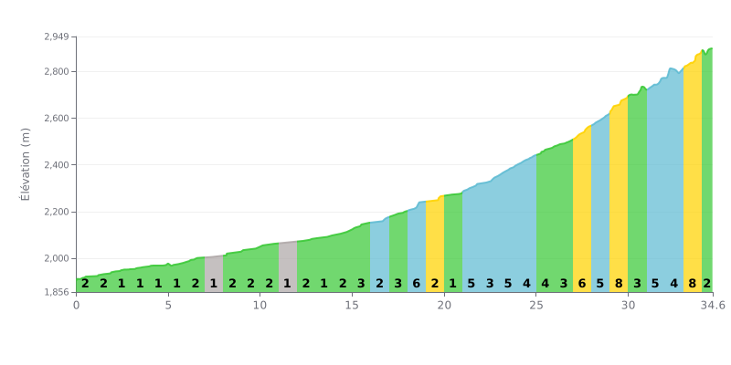
Difficulty breakdown: This 34.6 km climb has a two-part profile. The first 15 km (average gradient 1-2%) is a long, rolling approach. The real difficulty starts after KM 16, with a string of 5-8% sections, especially tough between KM 27 and 34 (ramps hitting 8%). The length combined with the steep finish is what earns it the Hors Catégorie rating.
Pacing advice:
1. Manage your pace: Ride in endurance mode over the first third (≈ up to KM 15) to save your legs. Whatever you do, don't go out too hard.
2. Prepare for the hard sections: The steepest gradients (6-8%) are concentrated in the second half. Tackle them in an easy gear with a steady rhythm to avoid blowing up.
3. Break it down mentally: Split the climb into three segments: the approach (KM 0-15), the heart of the climb (KM 16-28), and the final grind (KM 29-34.6). Focus on one segment at a time.
34.6 km • 1118 m D+
VAM: average climbing speed, based on elevation gain


Join thousands of cycling fans! Plan your rides, record your performance, track your progress and discover the finest climbs.
Live climb profile to pace your effort all the way to the top.

