
Sklithro is a climb of 10.5 kilometers (hors catégorie). Sklithro tops out at 799 m above sea level. It is located in Δημοτική Ενότητα Κιλελέρ, Αποκεντρωμένη Διοίκηση Θεσσαλίας - Στερεάς Ελλάδος, Ελλάς. The average gradient is 6.9% with a maximum of 13.9%. The climb has 722 meters of elevation gain.
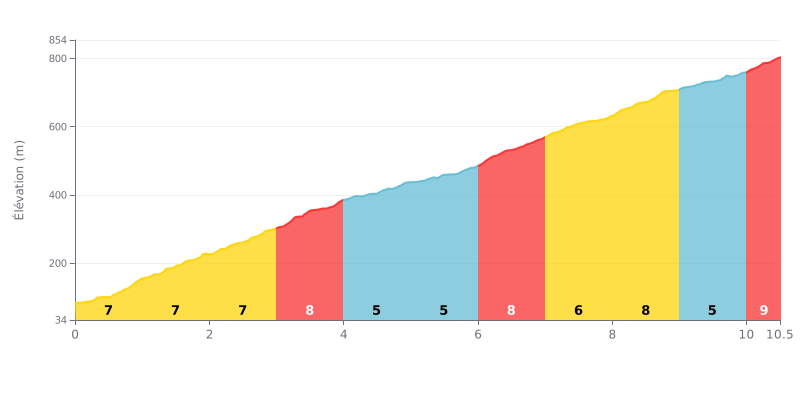
Analysis of difficulty: This 10.5 km HC climb is genuinely hard because of its uneven profile. The 6.9% average gradient is deceptive: three sections at 8% (km 2-4 and 6-7) and a final 500 meters at 9% demand disciplined pacing. The steepest kilometer (km 6.0-7.0 at 8.4%) comes right after a "gentler" stretch, which makes it a crucial point.
Pacing tips:
1. Manage the variations: Use the two kilometers at 5% (km 4-6) to recover actively before the tough km 6-7 section.
2. Save something for the finish: Keep some energy for the last 500 meters at 9%, the steepest part of the climb.
3. Choose your gear: The string of 8% sections calls for a gear that lets you keep a steady cadence without mashing.
10.5 km • 722 m D+
VAM: average climbing speed, based on elevation gain


Join thousands of cycling fans! Plan your rides, record your performance, track your progress and discover the finest climbs.
Live climb profile to pace your effort all the way to the top.

