
Ski Center Elatochori Pieria is a climb of 17.6 kilometers (hors catégorie). Ski Center Elatochori Pieria tops out at 1,427 m above sea level. It is located in Δήμος Κατερίνης, Αποκεντρωμένη Διοίκηση Μακεδονίας - Θράκης, Ελλάς. The average gradient is 7.2% with a maximum of 14.9%. The climb has 1261 meters of elevation gain.
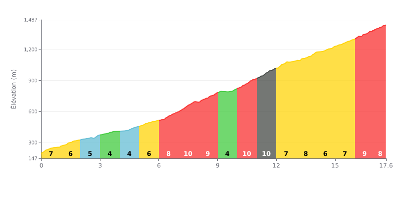
Climb breakdown: This HC climb covers 17.6 km at an average gradient of 7.2%, and it's the real deal. The second half is where it really bites, especially between km 7 and 12, where the gradient sits at a relentless 9 to 10%. The steepest kilometre (11.0-12.0 at 10%) comes after a string of tough sections.
How to manage the effort:
1. Pacing: Ease into the first 6 km (gradients of 3 to 8%) and save some matches for the hard part.
2. Focus on the key sections: Get your head and legs ready for the tough stretch from km 7 to 12 (gradients of 8 to 10%) by settling into a steady, efficient rhythm.
3. Use the breathers: Make the most of the km 9.0-10.0 section at 4% to recover and get ready for the two 10% kilometres that follow straight after.
Cyclists who have climbed to the Elatochori Ski Center describe a generally easy and well-maintained access road, often cleared of snow in winter. The climb through the conifer forest offers a preserved, peaceful natural setting, with superb views over the snowy peaks of the Pieria mountains. Reaching the top, with the wooden chalet, rewards the effort with a warm atmosphere.
The cyclists' experience is, however, mixed because of the heavy crowds on weekends and public holidays. Reports frequently mention traffic jams and parking difficulties that can spoil the ride. It is therefore strongly recommended to choose weekdays for a quieter climb.
For those who want to stop for a break, the Aloha chalet is described as a friendly spot to warm up with a coffee or a hot chocolate, although some find the prices a bit high. The atmosphere inside can be very lively, even noisy when music is playing, which not everyone enjoys.
In short, this climb is presented as a great accessible day out, especially for a midweek ride. Cyclists praise the beauty of the forest route, but advise avoiding peak times to fully enjoy the calm and serenity of the place.
17.6 km • 1261 m D+
VAM: average climbing speed, based on elevation gain


Join thousands of cycling fans! Plan your rides, record your performance, track your progress and discover the finest climbs.
Live climb profile to pace your effort all the way to the top.

