
Shingo River is a climb of 10.0 kilometers (hors catégorie). Shingo River tops out at 3,947 m above sea level. It is located in استور تحصیل, گلگت بلتستان, پاکستان. The average gradient is 8.5% with a maximum of 17%. The climb has 847 meters of elevation gain.
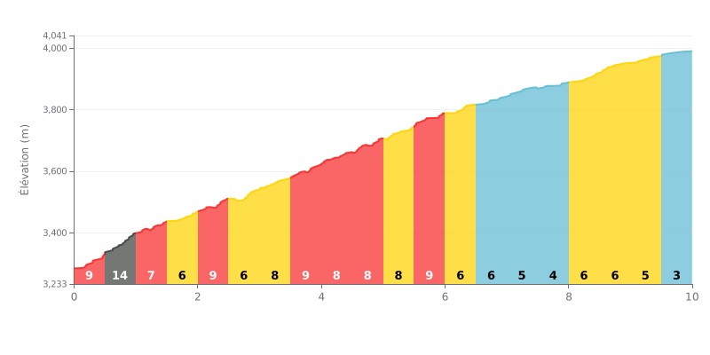
Difficulty breakdown: At 10 km with 847 m of elevation gain and an average gradient of 8.5%, this climb is rated HC (hors catégorie, beyond categorization). The hardest part comes in the first kilometer, with a section at 13% that demands a hard effort right from the bottom. The gradient then settles between 6% and 9% for about two-thirds of the climb, before easing to under 5% over the last 3 km.
How to pace the climb:
1. Start easy: Don't go out too hard. Keep your effort in check on the 13% ramp so you don't blow up your heart rate and burn your legs too early.
2. Find a steady rhythm: Settle into a consistent cadence between km 2 and 7, where the gradient holds steady at 6-9%. This is the key section for holding speed without wasting energy.
3. Finish strong: Use the last 3 km (under 5%) to pick up the pace a little and claw back any lost time, without going over the limit.
10.0 km • 847 m D+
VAM: average climbing speed, based on elevation gain


Join thousands of cycling fans! Plan your rides, record your performance, track your progress and discover the finest climbs.
Live climb profile to pace your effort all the way to the top.

