
Pirot climb is a climb of 11.2 kilometers (category 1). Pirot climb tops out at 1,013 m above sea level. It is located in Пирот, Централна Србија, Србија. The average gradient is 5.7% with a maximum of 13.8%. The climb has 644 meters of elevation gain.
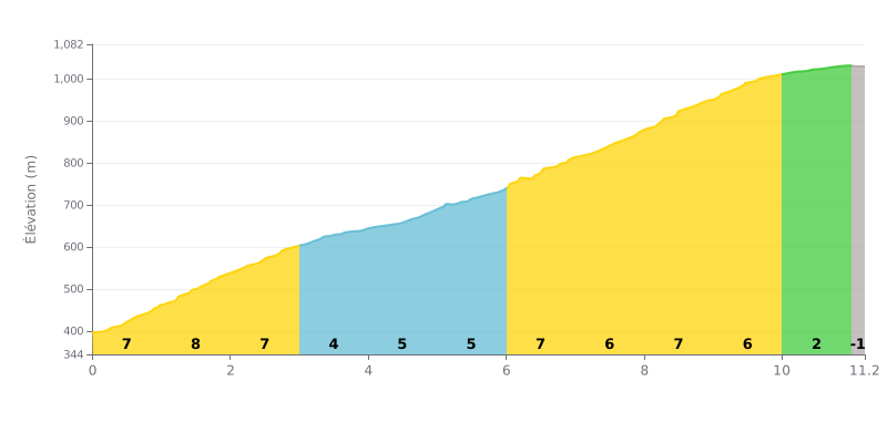
Climb analysis: This 1st category climb is a sustained effort with a demanding profile. The 5.7% average gradient over 11.2 km is deceptive: the first 3 km (7-8%) and the section from km 6 to km 10 (6-7%) are very steep, while there's a relative breather at km 10 (2%) before the finish.
Pacing advice:
1. Start controlled: Resist the temptation to go over the top in the first kilometres at 7-8%. Settle into a steady rhythm to save your legs for later.
2. Anticipate the sections: The hardest part comes between km 6 and 9 (gradients around 7%). Use the km 10 stretch at 2% to recover and come into the final with your effort under control.
3. Steady cadence: Pick a gear that lets you hold a smooth cadence (around 70-80 rpm) on the 5-7% sections, without surges.
According to cyclists' accounts, the climb up to the Vodopad Tupavica is an immersion in one of the most pristine gems of the Stara Planina. The road, whether ridden on a bike or walked, winds along the Dojkinačka reka through lush forest, offering a peaceful, refreshing setting well before you reach your goal.
The approach itself is part of the experience. While some reports say it's possible to drive up, riders point out that the dirt road (macadam) past the village of Dojkinci is pockmarked with potholes and can be rough, especially after rain. This stretch, although rideable on a bike, calls for some caution but rewards you with breathtaking scenery.
Arriving at the foot of the vodopad Tupavica is unanimously described as a magical moment. Riders talk about a waterfall with a truly unique character, with its reddish rocks covered in moss, that seems different with every season: thundering and powerful in spring, more intimate in summer, or turned into an ice sculpture in winter. The spot invites a contemplative break, with facilities to rest.
The accounts also remind us of a less idyllic reality: road access can be tough for vehicles, with a damaged bridge reported by several people, and some lament the litter left behind by careless visitors, a reason to stay extra vigilant to preserve this exceptional site.
In short, climbing this pass to discover the vodopad Tupavica is about far more than the physical effort: it's a complete sensory experience, where the sound of the water, the coolness of the woods and the raw beauty of nature create a lasting memory for any lover of the bike and of wide-open spaces.
11.2 km • 644 m D+
VAM: average climbing speed, based on elevation gain


Join thousands of cycling fans! Plan your rides, record your performance, track your progress and discover the finest climbs.
Live climb profile to pace your effort all the way to the top.

