
Pereval Arkhonskiy is a climb of 9.6 kilometers (hors catégorie). Pereval Arkhonskiy tops out at 2,204 m above sea level. It is located in Фиагдонское сельское поселение, Северная Осетия — Алания, Россия. The average gradient is 9.2% with a maximum of 16%. The climb has 890 meters of elevation gain.
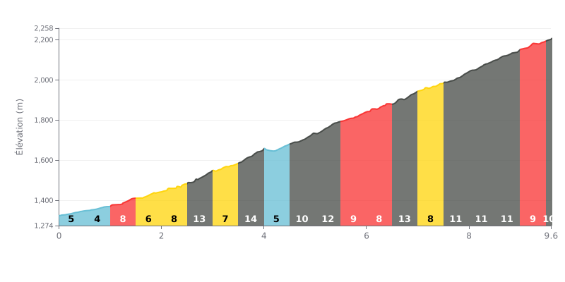
Difficulty analysis: This 9.6 km HC climb is hard all the way up, thanks to its high average gradient (9%) and the repeated very steep sections. The stretches from km 2.5-3.0 (13%), 3.5-4.0 (14%), 5.0-5.5 (12%) and 6.5-7.0 (13%) are especially brutal and demand disciplined pacing.
Pacing tips:
1. Set your rhythm from the gun: The first two kilometres (5-8%) are deceptively "easy". Use them to settle into a steady rhythm without going over your limit.
2. Prepare for the crux sections: Gradients above 12% come up several times. Drop into an easier gear as you approach these segments to keep your cadence smooth.
3. Make the most of the short breaks: The 5-7% stretches (like at km 4.0-4.5) give you brief moments to recover. Use them to ease off a little before the next section.
For riders who have tackled it, the Pereval Arkhonskiy is much more than just a climb: it's a full immersion in one of the most beautiful landscapes in North Ossetia. The route, which can start in the Kurtatin Gorge and drop down toward the "Beshënaya" river, serves up jaw-dropping views, especially between the summit and Verkhny Unal.
Riders describe a feeling of serenity and power. They talk about a place of silence, grace and a special kind of energy, a true "power spot" where you recharge while surrounded by stunning scenery, especially from the iconic "La chaise du bonheur" viewpoint or near the transmission tower.
The road itself is rideable, with reports indicating that in dry conditions, a light car can make it up, which suggests a decent surface. That said, access is seasonal: it's strongly advised not to attempt the climb in winter or early spring, when the road becomes impassable.
The unanimous advice from riders is to park the vehicle at the pass and explore the area on foot. Whether you head toward the tower or in the opposite direction, the beauty of the site really unfolds on a hike, especially in clear weather, to take in the epic panoramas.
9.6 km • 890 m D+
VAM: average climbing speed, based on elevation gain


Join thousands of cycling fans! Plan your rides, record your performance, track your progress and discover the finest climbs.
Live climb profile to pace your effort all the way to the top.

