
Passo Vlatanei is a climb of 16.8 kilometers (hors catégorie). Passo Vlatanei tops out at 1,211 m above sea level. It is located in Δήμος Πύλης, Αποκεντρωμένη Διοίκηση Θεσσαλίας - Στερεάς Ελλάδος, Ελλάς. The average gradient is 5.8% with a maximum of 12.7%. The climb has 979 meters of elevation gain.
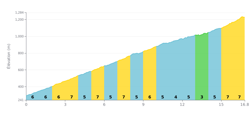
Difficulty analysis: This 16.8 km hors catégorie climb offers sustained difficulty with a demanding average gradient of 5.8%. The challenge lies in the consistency of the gradients (mostly between 5% and 7%) and the lack of any real respite, apart from a short 3% section between km 13 and 14. The final stretch is particularly brutal, with 7% over the last 1.8 km.
Pacing advice:
1. Stay steady: Settle into a constant rhythm suited to the 5.8% average gradient. Avoid surging on the 7% sections.
2. Save something for the finish: Hold some energy in reserve for the last 2 km (7%), the steepest part of the climb (74m of elevation gain).
3. Make the most of km 13-14: Use the short 3% section to recover and mentally prepare for the demanding final kilometres.
16.8 km • 979 m D+
VAM: average climbing speed, based on elevation gain


Join thousands of cycling fans! Plan your rides, record your performance, track your progress and discover the finest climbs.
Live climb profile to pace your effort all the way to the top.

