
Nikolaevskaya Sopka is a climb of 6.0 kilometers (category 2). Nikolaevskaya Sopka tops out at 485 m above sea level. It is located in Красноярск, Красноярский край, Россия. The average gradient is 4.7% with a maximum of 12%. The climb has 283 meters of elevation gain.
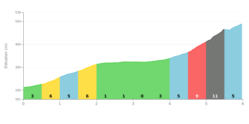
Difficulty breakdown: This 6 km climb has a two-part profile. The first section (km 0-2) is uneven, with moderate gradients (3-7%), followed by a long, almost flat section (km 2-4) at 1%. The real difficulty is concentrated at the end, with a demanding stretch of 9% and 10% over the last 1.5 km.
Pacing advice:
1. Make the most of the flat: The 2 km section at 1% (km 2-4) is a key opportunity to recover and bring your heart rate down before the steep ramps.
2. Save some in the tank: Avoid overpacing in the first kilometers. The decisive effort comes after km 4.5, where you'll need to handle a 9% gradient over 500 metres immediately followed by a section at 10%.
3. Anticipate the change of rhythm: The transition from the flat (1%) to the 5% gradient at km 4.0, then to 9%, is abrupt. Gradually pick up your cadence from km 4 so you're already up to speed when the difficulty hits.
For cyclists who have climbed the Nikolaevskaya Sopka, the ascent pays off with a huge reward: a jaw-dropping panoramic view over Krasnoyarsk and the Yenisei. Whether it's during the day with the city laid out below or at night when the lights twinkle, riders agree on a landscape that "grabs you by the eyes" and "takes your breath away".
The climb itself is, however, a mixed bag. The switchback road is described as impressive, but many riders point out that the surface deteriorates on some sections, with potholes and unpaved stretches. One point comes up again and again: the climb can be tricky to share with cars, with reports mentioning the lack of any safe provision for pedestrians and cyclists, forcing them to ride on the road itself.
Once at the top, the splendour of the view often contrasts with the facilities, which are considered lacking. Riders appreciate the modern observation platform, but several reports lament the absence of basic amenities such as toilets or some shelter from the elements. A strong, steady wind is consistently mentioned as something to plan for.
Despite these challenges, the overall experience remains memorable. Those who battled their way up come away with a real sense of accomplishment, stressing that the view at the top is well worth the effort. The advice that keeps coming back is to pick your moment carefully: aim for mild, dry weather to fully enjoy the view and avoid the extra difficulties on the road.
6.0 km • 283 m D+
VAM: average climbing speed, based on elevation gain


Join thousands of cycling fans! Plan your rides, record your performance, track your progress and discover the finest climbs.
Live climb profile to pace your effort all the way to the top.

