
Mount Hymettus is a climb of 13.5 kilometers (hors catégorie). Mount Hymettus tops out at 938 m above sea level. It is located in Δήμος Καισαριανής, Αποκεντρωμένη Διοίκηση Αττικής, Ελλάς. The average gradient is 7.2% with a maximum of 15.8%. The climb has 966 meters of elevation gain.
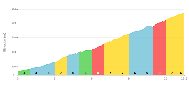
Difficulty analysis: This 13.5 km HC climb is sustained in difficulty, with an average gradient of 7.2%. The difficulty lies in the irregularity of the profile: after a moderate start (KM 0-3), a demanding central section (KM 6-9 at 7-8%) is followed by a relative breather (KM 9-10 at 5%), before the steepest kilometer at 9% between KM 11 and 12, which makes it the crux of the climb.
Pacing advice:
1. Managing your pace: Resist the temptation to go too hard in the easier early kilometers (3-4%). Use KM 5-6 at 3% to recover actively before the tougher central section.
2. Saving something for the finale: Keep some energy in reserve for the 9% kilometer (KM 11-12). This is the hardest part; tackling it in an easy gear with a steady cadence is crucial to avoid blowing up.
3. Breaking the climb down mentally: Divide the ascent into three sections: the Start (KM 0-5), the Demanding middle (KM 6-9), and the Finale with the peak difficulty (KM 10-13.5). This approach helps you stay focused and keep your effort under control.
According to riders, the Hymette climb is an immediate natural escape right at the gates of Athens. They describe a surprising feeling of being "so far from the capital" while being so close, with unspoiled nature and cleaner air. The main road is described as being in good condition, which makes the climb pleasant, but some reports warn about cars and motorbikes, especially at weekends, which can spoil the peace and quiet.
The scenery is a recurring highlight: the panoramic view over the whole Athens basin, all the way to the sea and the islands, is consistently described as "magnificent", "breathtaking" or "magical". The pine and cypress forest, although scarred by past fires, offers an oasis of greenery and plenty of side trails to escape the road. Riders also enjoy discovering little treasures such as the monasteries, chapels and ancient ruins scattered across the slopes.
In terms of difficulty, opinions are mixed. While the tarmac road is accessible, experienced riders go looking for the more technical, steeper tracks off the beaten path, especially on the Chalidou side. These sections are described as "wild", with rocky terrain and very steep gradients (over 30%), and they call for good preparation and a suitable mountain bike. Caution is essential, especially if the ground is wet and slippery.
The atmosphere is that of a meeting spot for lovers of nature and sport, where you come across families, hikers and other cyclists. The presence of a cantina halfway up is noted as a plus for a break. However, some reports point to problems with cleanliness (litter) and a lack of respect from some visitors for the environment, reminding us of the need to protect this precious "green lung".
13.5 km • 966 m D+
VAM: average climbing speed, based on elevation gain


Join thousands of cycling fans! Plan your rides, record your performance, track your progress and discover the finest climbs.
Live climb profile to pace your effort all the way to the top.


Within 20 km