
Mount Hermon(via Mas'ada) is a climb of 32.5 kilometers (hors catégorie). Mount Hermon(via Mas'ada) tops out at 2,094 m above sea level. It is located in מועצה אזורית גליל עליון, מחוז הצפון, ישראל. The average gradient is 6.0% with a maximum of 21.7%. The climb has 1959 meters of elevation gain.
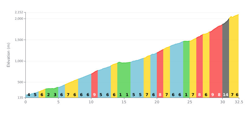
Difficulty analysis: This HC climb is a long grind (32.5 km) with a sustained average gradient of 6%. Its difficulty lies in the uneven profile: several sections above 8% (KM 10, 20, 26, 28-30) and a brutal finish at 14% at KM 30, after 30 km of effort. The flatter sections at 1-2% (KM 14-15, 24) are too short to offer any real recovery.
Pacing advice:
1. Ride within yourself for the first 20 km to save your legs, even on the 6-7% gradients. Avoid sudden surges on the 9% sections.
2. Use the short flat sections (KM 14-15 and 24) to briefly ease the pressure on your legs and get some fluids in, without breaking your rhythm.
3. Save something for KM 30, the steepest part at 14%, which demands a lot of power. Anticipate your shift down to an easier gear as you approach this decisive section.
32.5 km • 1959 m D+
VAM: average climbing speed, based on elevation gain


Join thousands of cycling fans! Plan your rides, record your performance, track your progress and discover the finest climbs.
Live climb profile to pace your effort all the way to the top.


Within 20 km