
Mount Hermon (via paved bike path) is a climb of 30.7 kilometers (hors catégorie). Mount Hermon (via paved bike path) tops out at 2,215 m above sea level. It is located in מועצה אזורית גליל עליון, מחוז הצפון, ישראל. The average gradient is 6.8% with a maximum of 22%. The climb has 2076 meters of elevation gain.
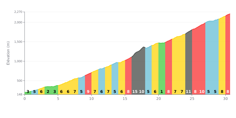
Difficulty breakdown: At 30.7 km, this climb is a true endurance test, the kind that earns beyond-category status. Its main challenge is the length combined with the 2076m of elevation gain. The profile is mostly steady at 6-8%, but it has two particularly hard sections: a 15% kilometre (KM 16-17) and an 11% stretch (KM 24-25), both coming after more than 15 km of effort.
Pacing advice:
1. Steady rhythm: Settle into a consistent tempo suited to the 6-8% gradients. Don't go into the red on the easier opening kilometres (2-4%), or you'll burn through your legs before the hard part.
2. Save something for the spikes: Keep some energy in reserve for the two steep sections (KM 16 and 24). Stand up on the pedals if needed to protect your legs and keep your cadence up.
3. Mental game: Break the climb into chunks. The brief flat-ish section at 1% (KM 20-21) is a chance to recover before the final, sustained push.
Cyclists who have climbed the Banias National Park pass describe an intense and out-of-this-world natural experience. The climb winds through a setting that contrasts sharply with the arid landscapes of the region: lush forest, powerful waterfalls and the constant sound of running water create a unique atmosphere, often compared to a "jungle" or a corner of Europe. The coolness coming off the stream and the shade of the trees make the effort more bearable, even on hot days.
In terms of difficulty, riders' reports agree that the climb is generally not considered very hard, but it demands some attention. The road has some sizeable ups and downs, along with sections featuring several steps or fairly steep climbs and descents. Some stretches can get slippery, especially after rain. The route isn't suited to bikes towing kid trailers, and it requires a decent level of fitness.
A recurring theme in the feedback is the frustration of not being able to go for a swim. Although the trail follows crystal-clear water and natural pools that are very tempting, swimming is strictly prohibited in the nature reserve to protect the ecosystem. Families with kids should be aware of this to avoid disappointment.
To make the most of the ride, cyclists recommend setting off early in the morning to avoid the heat and the crowds, especially on weekends and during school holidays. The best time of year is late winter and spring, when water flow peaks after the snowmelt, making the scenery even more spectacular.
30.7 km • 2076 m D+
VAM: average climbing speed, based on elevation gain


Join thousands of cycling fans! Plan your rides, record your performance, track your progress and discover the finest climbs.
Live climb profile to pace your effort all the way to the top.


Within 20 km