
Mount Gargash is a climb of 11.2 kilometers (hors catégorie). Mount Gargash tops out at 3,572 m above sea level. It is located in دهستان جوشقان قالی, استان اصفهان, ایران. The average gradient is 9.7% with a maximum of 18.9%. The climb has 1087 meters of elevation gain.
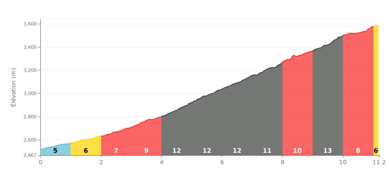
Climb analysis: This climb has a progressive profile with increasing difficulty. The first 4 km (5-9%) serve as a warm-up before a brutal stretch of five km at 12% between km 4 and 9. The hardest km (13%) comes at km 9, followed by a slight respite (8-6%) to the finish. The high average gradient of 9.7% over 11.2 km confirms its Hors Catégorie status.
Pacing advice:
1. Managing your pace: Start steady on the first, less steep km to save energy for the very demanding central section.
2. Anticipating the sections: Get ready mentally and physically for the five consecutive km at 12% and the 13% peak at km 9. Avoid surges and keep a steady rhythm.
3. Making the most of the finish: The last two km (8% then 6%) are your chance to kick on if you've paced your effort well, or to recover before the line.
11.2 km • 1087 m D+
VAM: average climbing speed, based on elevation gain


Join thousands of cycling fans! Plan your rides, record your performance, track your progress and discover the finest climbs.
Live climb profile to pace your effort all the way to the top.

