
Mount Arakan is a climb of 25.0 kilometers (hors catégorie). Mount Arakan tops out at 2,675 m above sea level. It is located in မင်းတပ်, ချင်းပြည်နယ်, မြန်မာ. The average gradient is 8.2% with a maximum of 24.3%. The climb has 2043 meters of elevation gain.
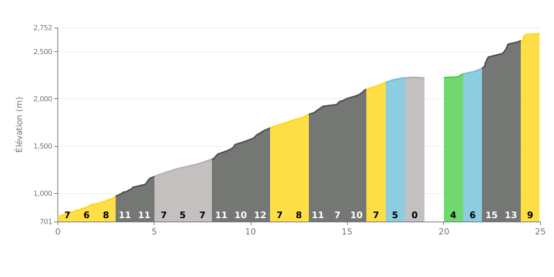
Difficulty breakdown: This 25 km HC climb is a major test thanks to its 2043m of elevation gain and its high average gradient (8%). The difficulty is compounded by uneven pacing: a demanding first third with sections at 11-12% before km 11, a significant flat between km 18 and 20, and an extremely brutal finale with two kilometres at 14% in the last three kilometres.
Pacing advice:
1. Managing your rhythm: Start within yourself to save your legs, especially on the 11-12% ramps at the bottom. Use the flat between km 18 and 20 to recover actively by spinning easily before the final assault.
2. Plan for the finale: Save something in the tank for the last 5 km, the steepest part at 14%. Adjust your gearing and cadence accordingly through this decisive section.
3. Hydration and refuelling: The length of the climb means you need to drink regularly from the start. If possible, plan a refuelling stop before km 18 so you tackle the final in the best shape.
For cyclists who have climbed the Chin Hills, the experience is defined by stunning natural beauty. Riders describe them as "magnificent hills" and a "wonderful" place, suggesting scenery that pays you back for the effort.
That beauty comes with a demanding and somewhat risky reality. Several riders point out that the climb is "a bit risky", and others mention a lack of information, which adds to the sense of adventure and challenge.
So the experience is a mix of rewards and hard work. It's summed up in simple but strong verdicts like "Good" or "ok", which suggests that riding the Chin Hills is a real adventure, where the difficulty is part of the memory.
25.0 km • 2043 m D+
VAM: average climbing speed, based on elevation gain


Join thousands of cycling fans! Plan your rides, record your performance, track your progress and discover the finest climbs.
Live climb profile to pace your effort all the way to the top.

