
Morad Hahar is a climb of 9.2 kilometers (category 1). Morad Hahar tops out at 354 m above sea level. It is located in מועצה אזורית מטה אשר, מחוז הצפון, ישראל. The average gradient is 4.5% with a maximum of 15.7%. The climb has 413 meters of elevation gain.
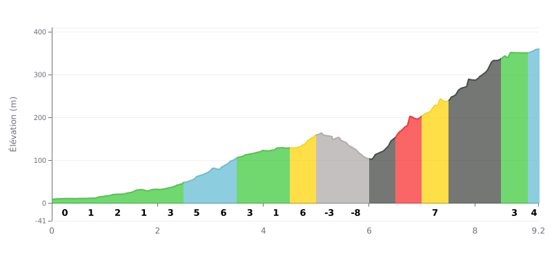
Climb difficulty analysis: This category 1 climb has a profile in three distinct acts. The first section (KM 0-5) is very gentle, with moderate gradients (1-6%) that let you settle into the effort nicely. Difficulty ramps up abruptly at KM 6 after a short technical descent (KM 5.5-6.0 at -8%). The heart of the climb (KM 6.0-8.5) is demanding, with a severe stretch of gradients between 7% and 11% over nearly 2.5 km. The finish comes on a more reasonable gradient (3-4%).
Tips for managing your effort:
1. Pacing: Use the easy start to find your rhythm without burning matches. The main effort should be dosed on the 11% section: stay within your target effort zone to avoid blowing up.
2. Prepare for the descent: The short descent before KM 6 is steep (-8%). Use it to recover actively without over-braking, but get yourself mentally and physically ready for the immediate attack on the 11% ramp.
3. Break it down mentally: Don't look at the climb as a whole. Focus on the succession of tough sections between KM 6 and 8.5. The gradient easing past KM 8.5 will be a well-earned reward.
9.2 km • 413 m D+
VAM: average climbing speed, based on elevation gain


Join thousands of cycling fans! Plan your rides, record your performance, track your progress and discover the finest climbs.
Live climb profile to pace your effort all the way to the top.

