
Mont Parthénion is a climb of 25.0 kilometers (hors catégorie). Mont Parthénion tops out at 1,251 m above sea level. It is located in Δημοτική Ενότητα Λέρνας, Αποκεντρωμένη Διοίκηση Πελοποννήσου, Δυτικής Ελλάδας και Ιονίου, Ελλάς. The average gradient is 5.2% with a maximum of 17.1%. The climb has 1293 meters of elevation gain.
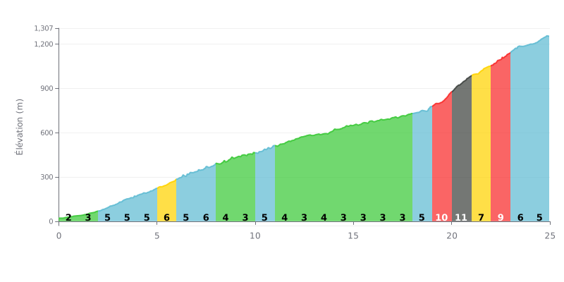
Difficulty breakdown: This 25 km climb has two distinct parts. The first 18 km are relatively moderate (average gradient of 4.2%), making for a long approach. The real difficulty is concentrated between km 19 and 23, with a brutal sequence of 10%, 11%, 7% and 9% that forms the heart of this HC climb.
Pacing advice:
1. Pace yourself on the first section (km 0-18) to save your energy. Don't overcook it: the gradient there is generally manageable.
2. Prepare for the wall between km 19-23, both mentally and physically, for sustained effort on this decisive stretch.
3. Manage your effort in the final part of the climb (km 23-25), where the gradient eases to 5-6%, so you can finish strong without blowing up.
25.0 km • 1293 m D+
VAM: average climbing speed, based on elevation gain


Join thousands of cycling fans! Plan your rides, record your performance, track your progress and discover the finest climbs.
Live climb profile to pace your effort all the way to the top.

