
Mont Pantokrator is a climb of 16.3 kilometers (hors catégorie). Mont Pantokrator tops out at 882 m above sea level. It is located in Άγιος Παντελεήμονας, Αποκεντρωμένη Διοίκηση Πελοποννήσου, Δυτικής Ελλάδας και Ιονίου, Ελλάς. The average gradient is 6.0% with a maximum of 19%. The climb has 974 meters of elevation gain.
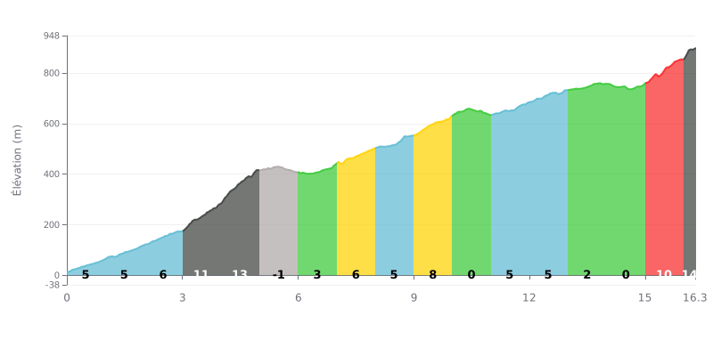
Difficulty analysis: This HC climb is genuinely hard, with two critical sections. The first is a wall between km 3 and 5 (gradients of 11% and 13%), and the second is a brutal finish, with the last 300 metres at 14%. The 0% sections (km 5-6, 10-11, 14-15) offer brief breathers to recover.
Pacing tips:
1. Handling the "wall" at the start: Don't go out too hard. Save something in the tank for the 13% ramp at km 4, the steepest part of the climb.
2. Make the most of the flat bits: Use the three 0% sections (around km 5, 10 and 14) to recover by spinning easy without stopping.
3. Plan for the finish: Save some energy for the last kilometre (10%) and especially the final 300 metres at 14%, where you'll need one more push.
From the accounts of riders who have climbed Mount Pantokrator, the ascent is a demanding but unforgettable experience. The road, though asphalted, is described as a long series of tight hairpins and steep pitches, especially over the final stretch. For many, the mechanical and physical challenge is part of the adventure, and the reward at the top more than justifies the effort.
At the summit, just under 1000 metres above sea level, riders are greeted by a truly breathtaking 360° panoramic view. On a clear day, the eye takes in the whole of Corfu, the Albanian coastline and, so they say, sometimes even Italy. This sight, especially at sunset, is consistently cited as the highlight of the climb, a "reward" that wipes out the fatigue of the ride up.
The atmosphere at the top is a little unusual, a mix of serenity and surprise. Riders discover a charming little monastery with an authentic character, but also a field of telecom antennas that, for some, spoils the scenery a bit. A small café lets you refuel while enjoying the view, although its opening hours are sometimes hit or miss. Accounts stress the unique sense of calm and grandeur at this high point.
Riders recommend that you prepare your climb properly: check your brakes, pick a day with very mild weather so you can fully enjoy the view, and be aware that the road, though generally in good condition, is narrow and shared with cars and motorbikes, so you need to stay alert at all times, especially on the hairpin bends.
16.3 km • 974 m D+
VAM: average climbing speed, based on elevation gain


Join thousands of cycling fans! Plan your rides, record your performance, track your progress and discover the finest climbs.
Live climb profile to pace your effort all the way to the top.

