
Mont Méron is a climb of 7.3 kilometers (category 1). Mont Méron tops out at 1,141 m above sea level. It is located in מועצה אזורית גליל עליון, מחוז הצפון, ישראל. The average gradient is 5.0% with a maximum of 11.6%. The climb has 366 meters of elevation gain.
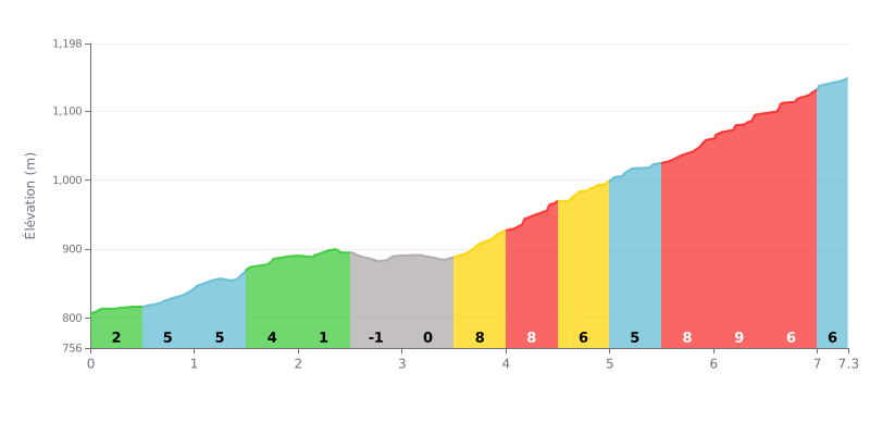
Analysis of the difficulty: This climb has a three-act profile. After a moderate start, a descending central section (KM 2.5-3.5) offers a deceptive breather. The real difficulty begins after KM 3.5 with a brutal 4 km stretch where the gradient constantly stays above 7%, peaking at 9%. The final part holds a steep gradient (6-8%), making the finish a real grind.
Tips for managing your effort:
1. Managing your pace on the false flat downhill: Use the slightly downhill section (KM 2.5-3.5) to recover actively without losing all your momentum, ahead of the hard part.
2. Preparing for the wall from KM 3.5: Tackle the steepest section (7% to 9%) with controlled power to avoid blowing up. This is where the climb gets decided.
3. Saving something for the finish: Even though the gradient eases slightly after KM 5.5, it stays sustained (6-8%). Don't empty the tank too early on the 8% pitches.
According to riders who have climbed it, the ascent of Mount Meron delivers a unique sensory experience from the very first metres: the air immediately gets cooler and crisper, even on a hot day, which is a welcome relief. The road winds through a green, unspoilt landscape, a true "roof of the Galilee", where the Mediterranean forest, made up of oaks and dense scrub, provides pleasant shade.
Riders agree that the effort is more than repaid by breathtaking panoramic views. On a clear day, the summit offers an incredible vista over much of northern Israel, from the Golan Heights down to the Sea of Galilee, and even the Bay of Haifa in the distance. That feeling of being on top of the country (Hermon aside) is a real highlight of the climb.
That said, riders warn that the approach can be considerably less idyllic. The access road is often described as being in poor condition, with plenty of potholes that demand constant attention. On top of that, reports warn of heavy traffic, especially at weekends and on public holidays, when jams are common and can spoil the ride.
Once at the top, the atmosphere is distinctive. An active military base on the highest point keeps riders from reaching the actual crest, something some find frustrating. However, a well-maintained trail ("Shvil HaPisga") loops around the summit and remains accessible, letting you fully enjoy the natural setting, although some riders complain about litter left behind by visitors.
Despite these drawbacks, the overall experience described is that of a must-do climb for lovers of altitude riding. The combination of the physical challenge, the exceptional coolness and the spectacular scenery leaves a lasting impression and fully justifies the effort, especially if you avoid the busy periods.
7.3 km • 366 m D+
VAM: average climbing speed, based on elevation gain


Join thousands of cycling fans! Plan your rides, record your performance, track your progress and discover the finest climbs.
Live climb profile to pace your effort all the way to the top.

