
Mont Kumgangsan is a climb of 33.8 kilometers (hors catégorie). Mont Kumgangsan tops out at 1,601 m above sea level. It is located in 온정리, 강원도, 조선민주주의인민공화국. The average gradient is 6.6% with a maximum of 21%. The climb has 2246 meters of elevation gain.
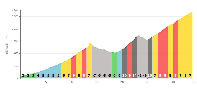
Difficulty analysis: This 33.8 km Hors Catégorie climb is a demanding test of endurance. Its difficulty lies in its length and steep gradients (averaging 7%), but above all in its uneven profile. Two significant descents (KM 14-18 and KM 23-25) break your rhythm and force you to dig back in for repeated efforts, especially on 10% ramps and a very steep 14% section (KM 22).
Tips for managing your effort:
1. Pacing: Start conservatively over the first kilometres (2-5%) to save your legs. The main effort begins after KM 9.
2. Prepare for the rhythm breaks: Use the descents (KM 14-18 and KM 23-25) to recover actively (spin the legs easily) without fully backing off, so you're ready for the hard surges that follow.
3. Focus on the key sections: The toughest stretch (KM 20-23, with 10% and 14% gradients) and the final part (KM 25-33.8, average gradient of 8%) demand concentration and total mental commitment.
For cyclists who have climbed the Kumgangsan pass, the experience stays unforgettable. Riders describe breathtaking scenery, with sculpted rocks and colourful forests framing valleys of emerald water. The cleanliness and peacefulness of the national park come up again and again, creating a unique atmosphere far from the hustle and bustle.
The climb itself is described as a physical challenge, with riders simply saying that "the mountain is hard". While the condition of the road isn't really detailed, the overall vibe is shaped by the visible presence of soldiers and the surrounding propaganda, which is a strong feature of the experience according to the accounts. The surrounding landscapes are described as contrasting, between the splendour of the mountain and some more barren stretches.
Despite the context, riders remember out-of-this-world moments, like the walk to the waterfalls or the jaw-dropping view from the summits. For many, Kumgangsan is much more than just a climb: it's a place loaded with emotion and hope for reunification, somewhere they hope to be able to visit freely again one day.
33.8 km • 2246 m D+
VAM: average climbing speed, based on elevation gain


Join thousands of cycling fans! Plan your rides, record your performance, track your progress and discover the finest climbs.
Live climb profile to pace your effort all the way to the top.

