
Mont Eres is a climb of 47.5 kilometers (hors catégorie). Mont Eres tops out at 5,142 m above sea level. It is located in 定日县 དིང་རི་རྫོང།, 西藏自治区 བོད་རང་སྐྱོང་ལྗོངས།, 中国. The average gradient is 3.6% with a maximum of 16.5%. The climb has 1709 meters of elevation gain.
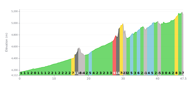
Difficulty breakdown: At 47.5 km, this climb is demanding because of its length, but its moderate average gradient of 3.6% makes it manageable over the distance. The real challenge is how it's broken up: sharp kicks (sections at 14% at km 16 and 28, and 9% at km 27) are interspersed with flat stretches and short descents (km 17, 18, 30, 40, 47), which disrupt your rhythm.
Pacing tips:
1. Settle into a steady rhythm: Resist the urge to go too hard in the first few kilometres, which are very flat. Save something in the tank for the three main walls (km 16-17 and km 27-29).
2. Use the descents to recover: The downhill sections (like km 30 at -24%) are crucial. Ease off, drink up and refuel without pushing it.
3. Anticipate the gradient changes: The finish is uneven (km 45 at 8%) before a final descent. Adjust your gearing accordingly to keep a steady cadence all the way to the top.
47.5 km • 1709 m D+
VAM: average climbing speed, based on elevation gain


Join thousands of cycling fans! Plan your rides, record your performance, track your progress and discover the finest climbs.
Live climb profile to pace your effort all the way to the top.

