
Mont Cithéron is a climb of 11.7 kilometers (hors catégorie). Mont Cithéron tops out at 1,025 m above sea level. It is located in Δημοτική Ενότητα Πλαταιών, Αποκεντρωμένη Διοίκηση Θεσσαλίας - Στερεάς Ελλάδος, Ελλάς. The average gradient is 6.8% with a maximum of 14%. The climb has 794 meters of elevation gain.
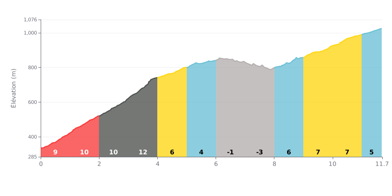
Difficulty analysis: This climb has a demanding profile. The first section is very steep (4 km at 9-12%) and accounts for most of the elevation gain. It is followed by a recovery section in the middle (gentle or even negative gradients between km 5 and 8), before a moderate but sustained effort to the summit.
Pacing tips:
1. Managing the start: Don't blow up from the bottom. The first 4 km are brutal (gradients above 9%). Settle into a steady, controlled rhythm to avoid cooking yourself early.
2. Making the most of the respite: Use the descent between km 6 and 8 to recover actively: spin the legs easily, keep drinking, and save your energy before the final difficulty.
3. Saving something for the finish: The last section (km 8-11.7), with gradients of 5-7%, requires you to ramp the effort back up. Keep something in the tank so you can hold a steady rhythm all the way to the summit.
Cyclists who have climbed Mount Cithaeron agree on one thing: the reward matches the effort. The climb, described as tough with a steep grade in places, demands "trained legs and lungs." But the effort pays off, because the view from the summit, at over 1400 metres above sea level, is consistently described as magical, breathtaking, offering a unique panorama over Central Greece, the Peloponnese and the Gulf of Corinth.
Access is mainly via a paved but narrow road that demands constant vigilance, especially on the bends. Riders also mention the weather: the wind can be strong and the cold biting, even in summer. The mood on the mountain is described as wild, with abandoned old military installations and wind turbines that, for some, spoil the natural idyll.
Beyond the sporting challenge, cyclists feel a sense of escape and connection with nature, all the more so since the place is steeped in intense mythological history, recalled in several accounts. It is this combination of hard physical effort, spectacular scenery and an atmosphere heavy with history that makes the ascent of Cithaeron so memorable for those who have ridden it.
11.7 km • 794 m D+
VAM: average climbing speed, based on elevation gain


Join thousands of cycling fans! Plan your rides, record your performance, track your progress and discover the finest climbs.
Live climb profile to pace your effort all the way to the top.

