
Mont Ainos is a climb of 19.7 kilometers (hors catégorie). Mont Ainos tops out at 1,585 m above sea level. It is located in Δημοτική Ενότητα Σάμης, Αποκεντρωμένη Διοίκηση Πελοποννήσου, Δυτικής Ελλάδας και Ιονίου, Ελλάς. The average gradient is 8.1% with a maximum of 16.3%. The climb has 1595 meters of elevation gain.
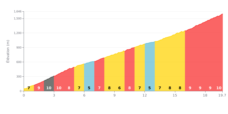
Difficulty analysis: This 19.7 km hors catégorie climb is a demanding test of endurance. Its difficulty lies in the combination of a long distance and a high average gradient (8.1%), with a particularly brutal finish (gradients of 9-10% over the last 4 km). The climb is tough from the very start, with a stretch of 9-10% gradients over km 1 to 4.
Tips for managing your effort:
1. Pace yourself from the bottom: Resist the urge to go too hard in the first kilometres at 9-10%. Settle into a steady rhythm you can hold for the long haul.
2. Save something for the final ramps: Keep some reserves for the last 4 km, where the gradient stays above 9% the whole way. Use the slightly easier sections (like km 5-7) to recover.
3. Manage your effort in stages: The gradient changes often. Adjust your gear and cadence to hold a steady power output rather than reacting to every surge in the terrain.
Riders who have climbed Mount Ainos describe it as a unique experience, one that takes you from Mediterranean heat into a cooler, wilder world. The road, which riders say is in very good condition and recently resurfaced over much of its length, winds through the national park and its Cephalonian maple forests, an endemic species with an intoxicating scent.
The climb is serious, topping out at 1628 metres, but the effort pays off. Riders report that the views from the various lookout points are simply breathtaking: on a clear day you can see the whole island, the Ionian Sea and neighbouring islands like Zakynthos and Ithaca. The atmosphere is peaceful, far from the bustle of the seaside resorts.
Riders agree on one point: it's crucial to check the weather before you set off. The summit can quickly be swallowed by cloud, hiding the view. Also, it's significantly cooler at the top than at sea level, even in peak summer, so a windbreaker is often needed. Some riders also mention the occasional presence of insects, such as wasps, which can be a nuisance on the way up.
Some riders found the final section, past the barrier, more technical or less inviting because of the antennas, but most agree the overall experience is unforgettable. For many, it's a must-ride that offers a unique perspective on the wild beauty of Cephalonia.
19.7 km • 1595 m D+
VAM: average climbing speed, based on elevation gain


Join thousands of cycling fans! Plan your rides, record your performance, track your progress and discover the finest climbs.
Live climb profile to pace your effort all the way to the top.

