
Mitsikeli is a climb of 17.9 kilometers (hors catégorie). Mitsikeli tops out at 1,697 m above sea level. It is located in Δημοτική Ενότητα Περάματος, Αποκεντρωμένη Διοίκηση Ηπείρου - Δυτικής Μακεδονίας, Ελλάς. The average gradient is 6.9% with a maximum of 14.9%. The climb has 1233 meters of elevation gain.
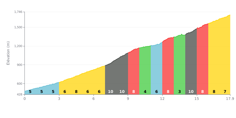
Difficulty breakdown: This 17.9 km HC climb is brutal thanks to its big elevation gain (1233m) and a sustained average gradient of 7%. It gets even harder with three key sections at 10% (km 7-9 and km 14-15), which demand disciplined pacing to avoid blowing up.
Pacing tips:
1. Settle into your rhythm early: The 5-6% gradients up to km 7 are your chance to find a good tempo without burning matches before the hard sections.
2. Prepare for the two "walls": Drop down a gear or two as you approach the 10% sections (around km 7 and 14) to keep a steady cadence and save your legs.
3. Make the most of the breathers: The easier stretches at 4% (km 10-11) and 3% (km 13-14) are good opportunities to recover actively without losing too much time.
17.9 km • 1233 m D+
VAM: average climbing speed, based on elevation gain


Join thousands of cycling fans! Plan your rides, record your performance, track your progress and discover the finest climbs.
Live climb profile to pace your effort all the way to the top.

