
Metzudat Koach is a climb of 4.4 kilometers (category 1). Metzudat Koach tops out at 384 m above sea level. It is located in מועצה אזורית גליל עליון, מחוז הצפון, ישראל. The average gradient is 6.8% with a maximum of 11.6%. The climb has 303 meters of elevation gain.
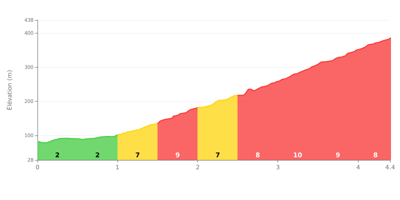
Difficulty breakdown: This Cat 1 climb has a deceptive profile. The first two kilometres (2% gradients) are very manageable, but the difficulty ramps up sharply from KM 1.0, with a sustained stretch of 7% to 10% gradients over the remaining 3.4 km. The hardest section comes between KM 3.0 and 3.5, where it hits 10%.
Pacing advice:
1. Pacing: Use the easy start (KM 0-1) to find a good rhythm without burning matches. Anticipate the sharp jump in gradient at KM 1.
2. Mental toughness: The real test is in the second half. Save something in the tank for the 9-10% ramps over the last 1.5 km.
3. Efficiency: Keep a steady cadence on the 7-8% sections so you don't blow up on the 10% wall.
Riders who have climbed to Metsoudat Koah describe a climb steeped in history. The road leads to a former British fortress that became a symbol of the War of Independence, where 28 fighters lost their lives. For many, the effort is closely tied to the moving, commemorative side of the place, with the Harout Museum (Rabbanut) and the soldiers' cemetery as standout stops.
The payoff, according to riders, is a spectacular viewpoint over the Hula Valley, the Golan Heights and, on a clear day, Mount Hermon. The fortress terrace offers a 360° panorama that more than justifies the effort and invites a long, contemplative break.
The climb itself is described as accessible but demanding. Riders mention a road in good condition, with a sustained grind that makes for a rewarding challenge without being extreme. The setting is appreciated for its calm and natural beauty, although some reports mention road traffic on certain stretches, so you need to ride with caution.
For those who want a bit more adrenaline, the site is the starting or finishing point for hiking trails, such as the one through Nahal Kadesh, described as technical and stunning. Riders like the option of combining the climb with a deeper exploration of the steep foothills of the Galilee.
4.4 km • 303 m D+
VAM: average climbing speed, based on elevation gain


Join thousands of cycling fans! Plan your rides, record your performance, track your progress and discover the finest climbs.
Live climb profile to pace your effort all the way to the top.


Within 20 km