
Mavriotissis is a climb of 2.6 kilometers (category 3). Mavriotissis tops out at 842 m above sea level. It is located in Καστοριά, Αποκεντρωμένη Διοίκηση Ηπείρου - Δυτικής Μακεδονίας, Ελλάς. The average gradient is 6.9% with a maximum of 13.6%. The climb has 180 meters of elevation gain.
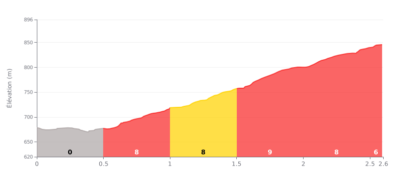
Difficulty analysis: This 2.6 km climb has an atypical profile. It opens with 500 metres of false flat descending (0%), followed by a steady 2 km section at 8%. The difficulty lies in that abrupt change of rhythm and in holding a sustained effort on the steep part, despite being a Cat 3 with a moderate average gradient of 6.9%.
How to manage the effort:
1. Anticipate the gradient change: Keep a high cadence on the flat opening to carry some momentum into the climb, but don't go out too hard.
2. Find your rhythm on the 8%: Once you hit the steep section, quickly settle into a cadence and power output you can hold for the full 2 km, or you'll cook yourself.
3. Ease off slightly near the top: The final 100 metres (not detailed above) have a lower average gradient, so you can adjust your effort there and finish strong.
2.6 km • 180 m D+
VAM: average climbing speed, based on elevation gain


Join thousands of cycling fans! Plan your rides, record your performance, track your progress and discover the finest climbs.
Live climb profile to pace your effort all the way to the top.

