
Mala Rijeka is a climb of 16.2 kilometers (hors catégorie). Mala Rijeka tops out at 1,080 m above sea level. It is located in Општина Бајина Башта, Централна Србија, Србија. The average gradient is 5.4% with a maximum of 12.6%. The climb has 876 meters of elevation gain.
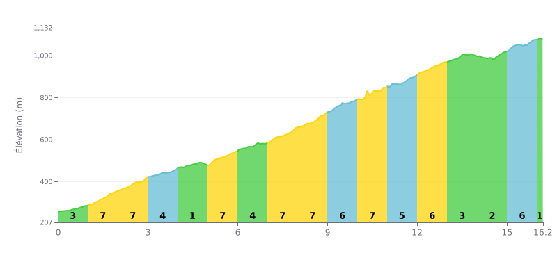
Difficulty breakdown: This 16.2 km beyond-category climb is genuinely hard because of its uneven profile. The 5.4% average gradient hides some big variations, with five kilometres at 7% (KM 1-3, 5, 7-8) making up the toughest stretches. There is a notable breather between KM 4 and 5 (1% gradient), but the overall effort is sustained, especially in the first half.
How to manage the effort:
1. Pace yourself from the start: The first three kilometres are tough (7%). Don't go out too hard, and find a heart rate or power output you can hold.
2. Make the most of the breather at KM 4: The 1% kilometre is a crucial chance to recover, drink and eat before the next run of steep sections.
3. Save something for the finish: The last two kilometres (KM 14-16) alternate between gentler gradients (3%) and a final 6% kicker. Keep some legs in reserve for that last ramp.
Cyclists who have climbed up to the Mala Rijeka bridge describe an breathtaking experience, dominated by the view over a deep canyon and an impressive structure. For many, simply seeing this viaduct, formerly the highest railway bridge in the world, is a real highlight, a "crown" of the route that stands out in a wild, rugged landscape.
Getting close to the bridge itself is, however, subject to restrictions. Riders report that the viaduct is guarded 24/7, with security guards and dogs. Cyclists say you're not allowed to get too close and that taking photos is "in theory" forbidden, a rule seen as a post-socialist relic.
Despite these restrictions, the overall experience is considered unforgettable and spectacular. Riding the road that winds through this valley offers jaw-dropping views of this feat of human engineering set in a "miraculous" and wild nature, a contrast that really sticks in your mind.
The road itself is described as offering a stunning view from the roadside. However, some riders mention a tricky access route, with part of the way blocked by a barrier, which makes it hard to reach the closest viewpoint directly.
16.2 km • 876 m D+
VAM: average climbing speed, based on elevation gain


Join thousands of cycling fans! Plan your rides, record your performance, track your progress and discover the finest climbs.
Live climb profile to pace your effort all the way to the top.

