
Maasser Cedar Forest is a climb of 8.9 kilometers (hors catégorie). Maasser Cedar Forest tops out at 1,790 m above sea level. It is located in فريديس, محافظة جبل لبنان, لبنان. The average gradient is 8.3% with a maximum of 17.1%. The climb has 741 meters of elevation gain.
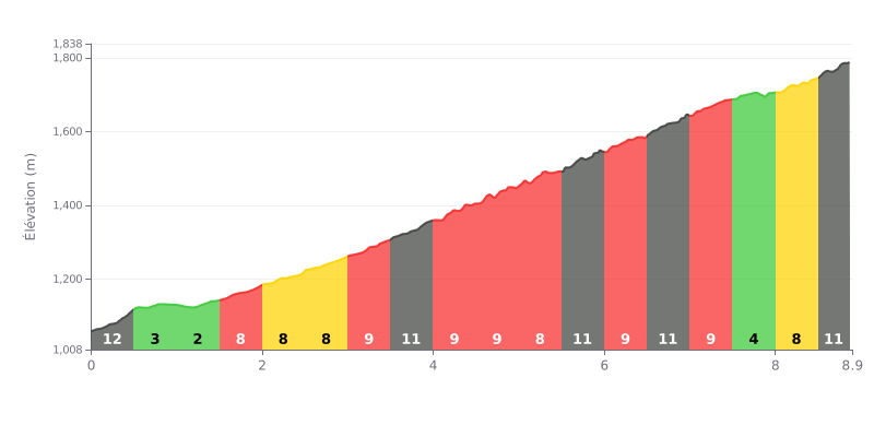
Difficulty analysis: This 8.9 km HC climb is hard because of its high average gradient (8.3%) and its big elevation gain (741m). The real difficulty is its irregularity: a very steep start (12%) is followed by a deceptive breather (KM 0.5-2.0), before a long stretch of punchy gradients (8-11%) between KM 2.0 and 7.5. The finish is brutal, with a final kilometer at 12%.
Pacing tips:
1. Handling the start: Don't get carried away by the steep opening ramp. Settle into a sustainable rhythm to avoid blowing up your legs and heart rate in the first few hundred meters.
2. Making the most of the breathers: Use the easier section (KM 0.5-2.0) to recover and find a steady breathing rhythm before the long, tough middle section.
3. Saving something for the finish: Keep some energy in the tank for the last few kilometers, especially the final 12% ramp, which will demand a big extra effort.
8.9 km • 741 m D+
VAM: average climbing speed, based on elevation gain


Join thousands of cycling fans! Plan your rides, record your performance, track your progress and discover the finest climbs.
Live climb profile to pace your effort all the way to the top.

