
Ma Pu Ti Pass is a climb of 43.8 kilometers (hors catégorie). Ma Pu Ti Pass tops out at 2,543 m above sea level. It is located in တောင့်တက်, မကွေးတိုင်းဒေသကြီး, မြန်မာ. The average gradient is 7.1% with a maximum of 19.7%. The climb has 3102 meters of elevation gain.
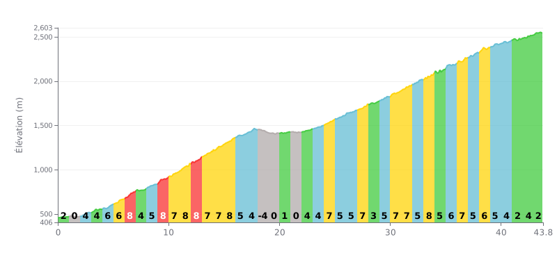
Difficulty breakdown: This climb is 43.8 km of pure endurance. The 7% average gradient is demanding, but it's the length and the 3102m of total elevation gain that make it hors catégorie. The real difficulty is the uneven profile: plenty of 8-9% sections (KM 6-7, 9-10, 11-13, 15, 33) alternate with flat stretches (KM 1-2, 19-22) and even a short descent (KM 18-19), which messes with your rhythm.
Pacing advice:
1. Manage your effort on the steep bits: Resist the urge to go over the top in the 8-9% sections. Hold a steady cadence and steady power to save your legs for the long haul.
2. Make the most of the flats: Use the low or zero gradient kilometres (around KM 20) to recover actively, easing off a little while keeping a good rhythm.
3. Save something for the end: The last 3 kilometres (2-4%) are less steep. Keep some energy in the tank to hold your speed all the way to the summit without "blowing up" in the final percentages.
For cyclists, the Taungup Pass is far more than just a mountain climb. It marks the border between the Bago Region and Rakhine State, a gateway to radically different landscapes.
Riders' accounts describe a climb that rewards the effort with jaw-dropping views. The bus ride, recommended if you have the time, confirms the place's reputation for breathtaking mountain panoramas.
Cyclists also mention an administrative quirk: it's common for immigration officers to check your passport or your National Registration Card (NRC) at the checkpoint.
Beyond the sporting challenge, riding up the Taungup Pass is therefore an immersion in the realities of getting around this region, where cycling adventure blends with an administrative setting and sweeping scenery.
43.8 km • 3102 m D+
VAM: average climbing speed, based on elevation gain


Join thousands of cycling fans! Plan your rides, record your performance, track your progress and discover the finest climbs.
Live climb profile to pace your effort all the way to the top.

