
Livaditi is a climb of 14.3 kilometers (hors catégorie). Livaditi tops out at 1,243 m above sea level. It is located in Δημοτική Ενότητα Σταυρούπολης, Αποκεντρωμένη Διοίκηση Μακεδονίας - Θράκης, Ελλάς. The average gradient is 7.8% with a maximum of 16.7%. The climb has 1113 meters of elevation gain.
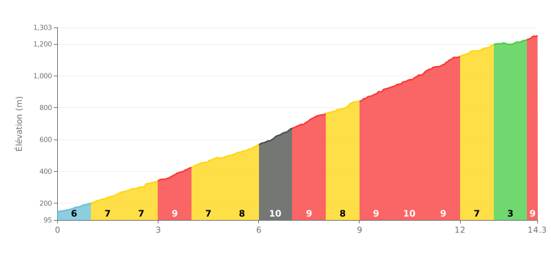
Difficulty analysis: This 14.3 km HC climb is brutal thanks to its high average gradient (8%) and its serious elevation gain (1113 m). The difficulty is ramped up by a particularly steep middle section, with gradients of 9-10% between KM 6 and KM 11. The easier finale (3% at KM 13) offers a breather before a short final ramp at 8%.
Pacing tips:
1. Pacing: Ease into it and save something in the tank for the steepest pitches (KM 6-11).
2. Watch for changes: The gradient changes often. Adjust your gearing and effort to each segment, especially when you hit the 10% section.
3. Use the breather: Use the 3% kilometer (KM 13) to recover and prepare for the final effort over the last 300 metres.
14.3 km • 1113 m D+
VAM: average climbing speed, based on elevation gain


Join thousands of cycling fans! Plan your rides, record your performance, track your progress and discover the finest climbs.
Live climb profile to pace your effort all the way to the top.

