
Kuh-e Genu is a climb of 32.5 kilometers (hors catégorie). Kuh-e Genu tops out at 2,319 m above sea level. It is located in دهستان تازیان, استان هرمزگان, ایران. The average gradient is 7.8% with a maximum of 17.2%. The climb has 2547 meters of elevation gain.
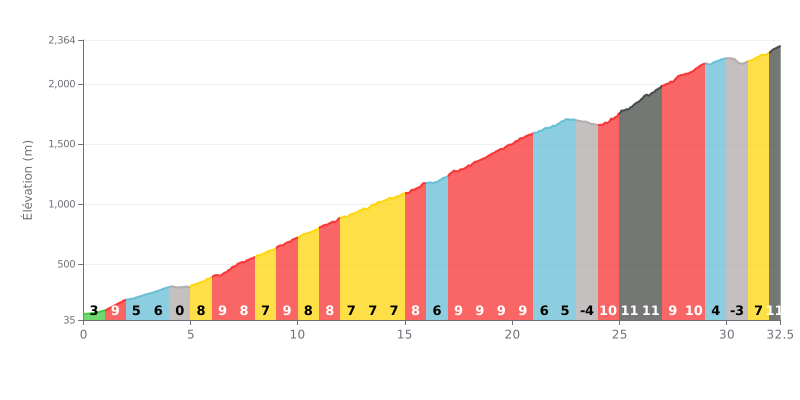
Difficulty analysis: An extremely demanding HC climb over 32.5 km. The difficulty comes from its length combined with a high average gradient (7.8%) and a particularly brutal finale, with ramps at 10-12% between km 24 and 28. The two short descents (km 23 and km 30) offer brief respite but do little to make up for the overall severity.
Pacing advice:
1. Steady rhythm in the first part: The first 15 km have varied gradients (0-9%). Avoid redlining on the 9% sections so you have something left for the much harder finale.
2. Save something for the hard finish: Keep some reserves for km 24 to 28, where the gradient stays above 9% throughout. The final section (km 32-32.5 at 11%) demands one last focused effort.
3. Make use of the flat sections: The flat km (km 4-5) and the gentle descents (km 23-24, km 30-31) are key for recovering and taking on food and drink without losing momentum.
32.5 km • 2547 m D+
VAM: average climbing speed, based on elevation gain


Join thousands of cycling fans! Plan your rides, record your performance, track your progress and discover the finest climbs.
Live climb profile to pace your effort all the way to the top.

