
Kopaonik is a climb of 25.9 kilometers (hors catégorie). Kopaonik tops out at 1,724 m above sea level. It is located in Општина Рашка, Централна Србија, Србија. The average gradient is 5.0% with a maximum of 14.1%. The climb has 1288 meters of elevation gain.
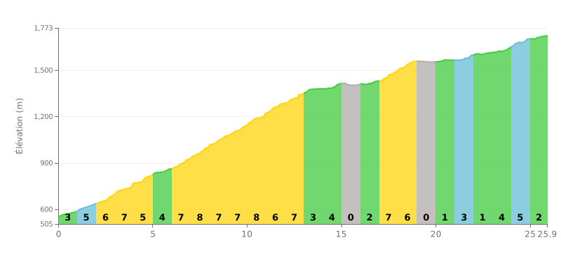
Difficulty breakdown: This hors catégorie climb covers 25.9 km and is genuinely hard because of its uneven profile. The 5% average gradient hides some tough sections, notably a stretch of 7-8% gradients between km 6 and km 12. The easier parts (km 13-16, 19-22) give you a chance to recover, but the total length and the serious elevation gain on the steep segments make this a real endurance test.
How to manage your effort:
1. Find a steady rhythm and don't go over the limit in the first kilometres (4-6% gradients). The main effort comes between km 6 and km 12.
2. Make the most of the flatter stretches (km 15-16, km 19-22) to recover actively by keeping a smooth cadence without pushing too hard.
3. Manage your gearing on the 8% sections to keep your heart rate steady and save your legs for the final part of the climb.
25.9 km • 1288 m D+
VAM: average climbing speed, based on elevation gain


Join thousands of cycling fans! Plan your rides, record your performance, track your progress and discover the finest climbs.
Live climb profile to pace your effort all the way to the top.

