
Khunjerab Pass is a climb of 75.8 kilometers (hors catégorie). Khunjerab Pass tops out at 4,716 m above sea level. It is located in تحصیل ہنزہ بالائی, گلگت بلتستان, پاکستان. The average gradient is 5.3% with a maximum of 18.3%. The climb has 4037 meters of elevation gain.
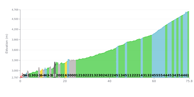
Difficulty breakdown: At 4037m of climbing over 75.8km, this ascent is extremely long, but its average gradient of 5.3% is moderate. The challenge lies in the endurance required and the key sections: the 12% kilometre (KM 15-16) and the steeper finish (5-6% gradients over the last 15km). The numerous flat sections (0-1% gradient) give you chances to recover.
Pacing advice:
1. Pace yourself during the first hour, despite the temptation to attack the steep start (8%), and use the descents (KM 1-2, KM 10-11) to recover without forcing it.
2. Save something in the tank for the tougher final section from KM 60 on, where gradients consistently exceed 4%. On the flat parts, ease off the pressure without stopping.
3. Plan ahead for the hard stretch at KM 15-16 (12%) by shifting into an easy gear in advance so you don't lose your rhythm.
For cyclists who have climbed the Kunjirap Daban (or Khunjerab Pass), the ride is described as a major achievement. It's the highest paved border crossing in the world, and reaching the summit at nearly 4700 metres above sea level gives a unique feeling, like you're standing on the roof of Pakistan.
The reward matches the effort: breathtaking scenery with majestic mountains, glaciers and snow-filled valleys, even in summer. Riders' accounts talk about an incredibly pure atmosphere, an awe-inspiring silence and unexpected encounters, like yaks grazing by the road or warm exchanges with fellow travellers and the border guards on the Chinese side.
Riders stress that the climb is no walk in the park. Thin air is a real challenge; you have to spin smoothly, avoid any sudden efforts and acclimatise well. The road, the famous Karakoram Highway, is generally described as being in good shape, a real feat of engineering, but it can be prone to rockfalls, especially depending on the weather.
Preparation is key. Riders recommend checking your bike and your fuel (the last town is Sost), packing very warm clothing (it's freezing and unpredictable, even in July), and bringing food and water, as there is no infrastructure at the top. It's a spartan experience, but an authentic one.
Despite the bitter cold and the punishing altitude, riders agree that it's an unforgettable adventure. The combination of the physical challenge, the raw beauty of the Karakoram landscapes and the symbol of peace represented by this border between Pakistan and China makes this climb truly unique and deeply rewarding.
75.8 km • 4037 m D+
VAM: average climbing speed, based on elevation gain


Join thousands of cycling fans! Plan your rides, record your performance, track your progress and discover the finest climbs.
Live climb profile to pace your effort all the way to the top.

