
Kfar HaHoresh is a climb of 7.1 kilometers (category 1). Kfar HaHoresh tops out at 440 m above sea level. It is located in מועצה אזורית עמק יזרעאל, מחוז הצפון, ישראל. The average gradient is 4.9% with a maximum of 14%. The climb has 351 meters of elevation gain.
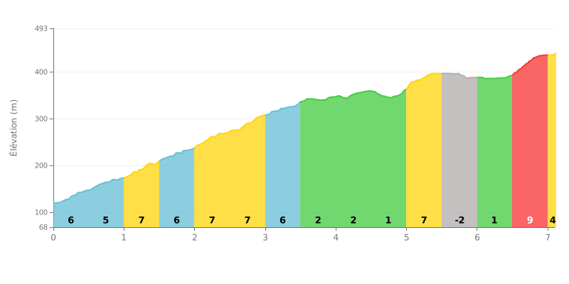
Difficulty breakdown: This Category 1 climb is moderate over its total distance (7.1 km at 4.9%), but the profile is very uneven. The real work is concentrated in the first 3.5 km, with gradients of 5 to 7%, followed by a clear recovery section of 2 km at just 1-2%. The finish is demanding, with a final kilometre at 8% after a short descent.
Pacing tips:
1. Start controlled: Resist the urge to go out too hard on the steep first 3 km. Save something in the tank for the finish.
2. Make the most of the flat: The middle section (KM 3.5 to 5.0) is your chance to recover by easing off slightly without losing momentum.
3. Prepare for the finish: Get your head and legs ready before KM 6.5 so you hit the 8% ramp already back in a strong rhythm.
7.1 km • 351 m D+
VAM: average climbing speed, based on elevation gain


Join thousands of cycling fans! Plan your rides, record your performance, track your progress and discover the finest climbs.
Live climb profile to pace your effort all the way to the top.

