
Kalavryta Ski Center is a climb of 14.5 kilometers (hors catégorie). Kalavryta Ski Center tops out at 1,675 m above sea level. It is located in Δημοτική Ενότητα Καλαβρύτων, Αποκεντρωμένη Διοίκηση Πελοποννήσου, Δυτικής Ελλάδας και Ιονίου, Ελλάς. The average gradient is 6.6% with a maximum of 13.3%. The climb has 963 meters of elevation gain.
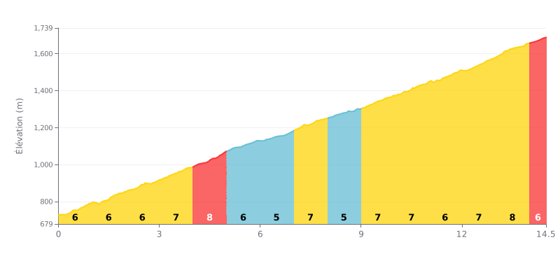
Difficulty analysis: This 14.5 km beyond category climb offers sustained but steady difficulty. The average gradient of 7% is consistent over most of the route, with one kilometre noticeably steeper (9% between KM 4 and 5) and two slightly easier sections (5% at KM 5-6 and 8-9) that give you brief respites. With no extreme gradients (>10%), this climb is demanding because of its length and consistency rather than sharp, punchy ramps.
Tips for managing your effort:
1. Consistency above all: Settle into a steady rhythm matching the 7% average gradient. Avoid overcooking it in the 9% kilometre to save your legs.
2. Make the most of the recoveries: Use the two 5% sections (KM 5-6 and 8-9) to ease off slightly and recover without losing too much time.
3. Mental management: The consistency of the profile lets you set goals by 1 km segments. Focus on one kilometre at a time to keep your effort going over the distance.
Riders who have climbed to the Kalavrita Ski Center describe a tough but beautiful ride. The road snakes up for about 14 km from the town of Kalavryta, with significant elevation gain taking you from 700 meters to over 1700 meters. Riders say the effort is more than repaid by jaw-dropping scenery, including a spruce forest that makes the climb very pleasant, especially in summer.
Road surface is an important point raised by riders. Some sections are described as well paved, but others have potholes and plenty of switchbacks, sometimes in poor condition, so you need to keep your eyes on the road. Traffic, especially motorbikes and cars, can be present, particularly on weekends, and that can make the climb hairy. It's therefore advisable to ride on weekdays for a more peaceful experience.
The vibe at the top is described as unique. Riders talk about incredibly clean air and a real sense of calm, with a stunning view over the mountains of the Peloponnese. Even without snow, the spot offers an exceptional setting for a well-earned break. There's a chalet where you can refuel, although some riders mention high prices.
In short, this climb is seen as a rewarding challenge for cyclists looking for nature and a real test of themselves. Riders recommend good fitness, picking a quiet day, and, if possible, checking road conditions beforehand so you can fully enjoy this great riding adventure in the heart of Helmos.
14.5 km • 963 m D+
VAM: average climbing speed, based on elevation gain


Join thousands of cycling fans! Plan your rides, record your performance, track your progress and discover the finest climbs.
Live climb profile to pace your effort all the way to the top.

