
Hiking Shelter is a climb of 9.6 kilometers (category 1). Hiking Shelter tops out at 719 m above sea level. It is located in Голубинское сельское поселение, Автономна Республіка Крим, Україна. The average gradient is 5.6% with a maximum of 16.1%. The climb has 531 meters of elevation gain.
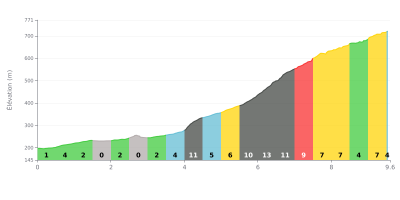
Difficulty analysis: This Category 1 climb has two distinct phases. The first 4 km are relatively gentle (average gradient of 2.1%), which makes for a deceptive warm-up. The real difficulty starts after KM 4.0, with a demanding 4 km section where the gradient constantly stays above 9%, peaking at 13% between KM 6.0 and 6.5. This central part is clearly the most selective.
Tips for managing your effort:
1. Pacing the first part: Resist the temptation to go too hard over the first few flatter kilometers. Use this section to find a steady breathing rhythm and save your energy.
2. Preparing for the wall from KM 4: Go into the 4-8 km stretch (11%, 10%, 13%, 11%) mentally and physically ready. Shift to an easier gear right at the start of this section to keep a high cadence and avoid blowing up your legs.
3. Recovering on the brief respite: The short easing between KM 8.5 and 9.0 (4%) is your chance to recover a little before the final push over the last 500 meters at 7%.
9.6 km • 531 m D+
VAM: average climbing speed, based on elevation gain


Join thousands of cycling fans! Plan your rides, record your performance, track your progress and discover the finest climbs.
Live climb profile to pace your effort all the way to the top.

