
Gorny Vozdukh is a climb of 2.2 kilometers (category 2). Gorny Vozdukh tops out at 290 m above sea level. It is located in Южно-Сахалинск, Сахалинская область, Россия. The average gradient is 9.4% with a maximum of 16.8%. The climb has 211 meters of elevation gain.
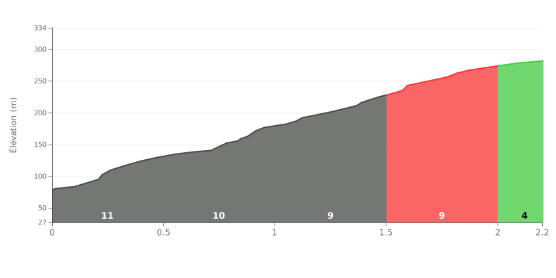
Climb breakdown: This 2.2 km climb is a sustained grind with a brutal average gradient of 9%. The crux is the opening 1.5 km at 10%, which demands a hard, steady effort before the gradient eases off over the final 700 metres.
How to pace it:
1. Start controlled: Don't go out too hard on the first kilometre at 10%. Settle into a rhythm you can hold for the whole climb.
2. Plan for the change in gradient: The climb eases noticeably after 2.0 km (4%). Save something in the tank to attack or recover on this easier final section.
3. Mental strategy: Split the climb into two parts: the 1.5 km at 10%, then the 0.7 km that are more manageable. It helps keep your focus.
From what cyclists report, the climb up to Gorny Vozdukh is one that sticks with you, mostly for the jaw-dropping panoramic view over Yuzhno-Sakhalinsk and, on a clear day, the ocean. The complex sits right in the middle of town, which is a major plus: getting there is very easy, whether you ride up from the centre or walk.
Riders describe a demanding but rewarding climb. The road winds through unspoiled nature, with pine forests and plenty of fresh air. Several accounts mention a hard effort, especially for those who tackle the slope on foot or on a mountain bike, but the payoff at the top, with the breathtaking scenery, quickly makes you forget the grind.
The infrastructure gets good marks, with a modern, smooth gondola that gets you up effortlessly so you can enjoy the viewpoint. That said, some riders point out that the access paths or roads can be damaged or poorly maintained outside of winter, with signs of roadworks and stretches of gravel, which can make the descent by bike a bit technical.
The atmosphere at the top is described as unique, with the option of grabbing a bite in a café while taking in the panorama. For cyclists, it's the chance to combine sporting effort with a moment of contemplation. The sense of pushing your own limits when you reach the summit, whether on the strength of your legs or by gondola, is a feeling everyone shares, and those who have done it highly recommend it.
2.2 km • 211 m D+
VAM: average climbing speed, based on elevation gain


Join thousands of cycling fans! Plan your rides, record your performance, track your progress and discover the finest climbs.
Live climb profile to pace your effort all the way to the top.

