
Golyam Perelik is a climb of 19.8 kilometers (hors catégorie). Golyam Perelik tops out at 2,159 m above sea level. It is located in Смолян, Смолян, България. The average gradient is 6.3% with a maximum of 13.3%. The climb has 1240 meters of elevation gain.
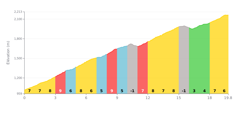
Difficulty analysis: This 19.8 km HC climb is genuinely hard, with a sustained average gradient of 6%. The real challenge is the uneven profile: several stretches at 8-9% (KM 2-4, 8, 11-14) broken up by shorter, easier sections, or even two short descents (KM 10 and KM 15) that disrupt your rhythm.
Pacing tips:
1. Manage the changes in gradient: Don't overcook it on the 9% sections. Use the 5% stretches and the short descents to recover actively without slowing down too much.
2. Spin an easy gear: Frequent changes in gradient mean you need to manage your gearing well to keep a steady cadence and avoid blowing up.
3. Save something for the finish: The last 4 km (KM 16-19.8) are less steep (4-7%), so keep some legs in reserve to attack over that final section.
According to riders who have climbed Goljam Perelik, the ascent is described as a pleasant, accessible experience. Riders regularly call it "very easy", "light" or "not hard", which makes it a target within reach of many cyclists, even in winter. The effort is more than repaid by the beauty of the place.
What strikes climbers most is the beauty of the scenery and the clean air. The gendikas that open up along the climb are unanimously praised as "magnificent", "unique" and "jaw-dropping" views over the Rhodope Mountains. The mood is perfect for unwinding and recharging in unspoiled nature.
Reports agree on one point, however: you cannot reach the exact summit. It is occupied by a military base and fenced off. Cyclists can get to within about thirty metres of the highest point, but the final access is forbidden, an important detail to know so you're not disappointed.
The last stretch is best done on foot from Perelik hut, a pleasant walk of about an hour. Some riders mention driving as far as possible, but others feel "the mountain isn't made for cars" and recommend parking lower down to fully enjoy the walk.
19.8 km • 1240 m D+
VAM: average climbing speed, based on elevation gain


Join thousands of cycling fans! Plan your rides, record your performance, track your progress and discover the finest climbs.
Live climb profile to pace your effort all the way to the top.

