
Emei Mountain is a climb of 35.4 kilometers (hors catégorie). Emei Mountain tops out at 2,535 m above sea level. It is located in 镇江, 四川省, 中国. The average gradient is 6.1% with a maximum of 20.4%. The climb has 2171 meters of elevation gain.
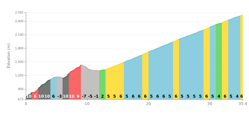
Difficulty analysis: This hors catégorie climb is extremely demanding over its distance (35.4 km) and its total elevation gain (2171 m). Its difficulty lies in the succession of very steep sections (several stretches at 10%) in the first part, followed by short descents that break your rhythm, then a long sequence of steady gradients between 5% and 6% all the way to the summit.
Pacing advice:
1. Start controlled: Hold back in the first kilometres (9-10%) to avoid blowing up your legs and your heart rate right from the start.
2. Make the most of the descents: The downhill sections (KM 5-6 and 9-12) are key for recovering actively, easing off the pedals without stopping completely.
3. Steady rhythm: From KM 12, find a sustainable tempo around 5-6% gradient and hold it until the finish, since consistency is the key on such a long climb.
Cyclists who have climbed Mount Emei describe a demanding climb, with significant elevation gain to over 3,000 metres above sea level. Riders mention plenty of steps and steep gradients, but the effort is well worth it.
The ride is defined by spectacular, ever-changing scenery. On a clear day, the view from the summit, especially the "sea of clouds", is described as absolutely stunning and unforgettable. However, many riders warn that the weather is often unpredictable, with fog or rain that can cut visibility, so it's crucial to check the forecast carefully before you set out.
Beyond the sporting challenge, the climb offers a unique cultural and spiritual immersion. Riders report discovering sacred temples, the peaceful atmosphere of the site, and the sight of the golden Buddha statue at the Golden Summit. Monkeys along the route add a touch of wildlife to the adventure.
Riders also note that the infrastructure is well developed, with the option of taking a bus or cable car for part of the way. They advise bringing warm clothing, even in summer, because of the big temperature difference between the base and the summit.
35.4 km • 2171 m D+
VAM: average climbing speed, based on elevation gain


Join thousands of cycling fans! Plan your rides, record your performance, track your progress and discover the finest climbs.
Live climb profile to pace your effort all the way to the top.

