
Elyakim is a climb of 9.3 kilometers (category 3). Elyakim tops out at 219 m above sea level. It is located in מועצה אזורית חוף הכרמל, מחוז חיפה, ישראל. The average gradient is 2.2% with a maximum of 7.3%. The climb has 203 meters of elevation gain.
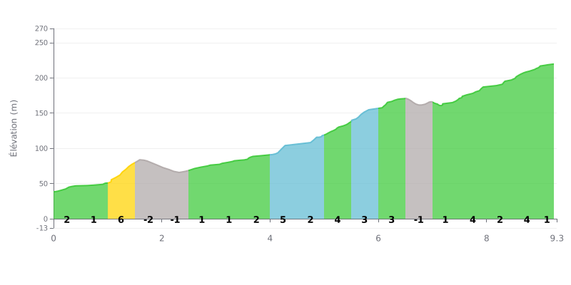
Difficulty analysis: This Category 3 climb is fairly easy overall (2.2% average), but it has a key section between km 1.0 and 1.5 at 6%, the steepest part of the climb. The profile is uneven, with two short descents (km 1.5-2.5) that break your rhythm, followed by a long stretch of moderate gradients (2-4%) from km 4.0.
Tips for managing your effort:
1. Handle the early spike: Don't be fooled by the average gradient. Anticipate the 6% kilometer and ease off so you don't blow up early.
2. Make the most of the recoveries: Use the two short downhill sections (km 1.5-2.5) to recover actively (spin easy) before the long, steady climb.
3. Find a steady rhythm: From km 4.0, the gradient settles around 3-4%. Settle into a constant rhythm you can hold all the way to the top.
9.3 km • 203 m D+
VAM: average climbing speed, based on elevation gain


Join thousands of cycling fans! Plan your rides, record your performance, track your progress and discover the finest climbs.
Live climb profile to pace your effort all the way to the top.

