
Cyllène Pass is a climb of 8.6 kilometers (hors catégorie). Cyllène Pass tops out at 1,583 m above sea level. It is located in Δημοτική Ενότητα Φενεού, Αποκεντρωμένη Διοίκηση Πελοποννήσου, Δυτικής Ελλάδας και Ιονίου, Ελλάς. The average gradient is 9.0% with a maximum of 15.7%. The climb has 772 meters of elevation gain.
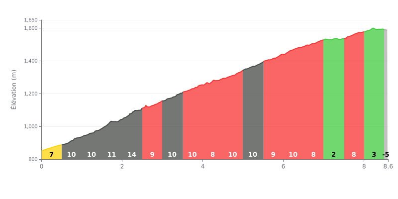
Difficulty analysis: This HC climb is a sustained effort, with a high average gradient (9%) over a serious distance. The hardest section comes between km 2.0 and 2.5, where the road averages 13%. There's a welcome break at km 7.0-7.5 (1%), but the climb finishes with a steep ramp (8%) before the line.
Pacing tips:
1. Pace yourself: Resist the urge to go too hard in the early kilometres, which hit 11-13%. Stay in a comfortable gear and keep a steady cadence.
2. Use the break: Spin your legs over the 1% section around km 7.0-7.5 to recover before the tough finale.
3. Save something for the finish: The gradient ramps back up to 8% after 7.5 km, so keep some in the tank for this last hurdle before the finish.
Riders who have climbed Mount Cyllene describe pristine nature and scenery that takes your breath away. The mountain is covered in a unique fir forest and alpine lakes, and from the summit you get a stunning panoramic view, with the Gulf of Corinth and the neighbouring peaks laid out below. The vibe is usually quiet and far from the crowds, ideal for anyone looking to escape into the wild.
The climb from the Ziria ski centre is generally considered accessible, even for beginners. However, riders' reports stress that the difficulty varies a lot with the season. In winter, snow and ice make the climb much harder and call for proper gear (crampons, poles). Some riders also mention that in places the route feels more like a hike-a-bike than a well-marked trail.
The experience can be affected by how busy it is. Some riders report heavy traffic on weekends and public holidays, leading to parking problems and queues at the facilities. Others point to the many horse trails that criss-cross the landscape. Even so, the beauty of the place is what most riders come back talking about.
The area is also appreciated for its welcoming side. Riders mention traditional villages with cosy tavernas and cafés where you can refuel after the effort, which makes the climb a complete experience, mixing sporting challenge and relaxation.
8.6 km • 772 m D+
VAM: average climbing speed, based on elevation gain


Join thousands of cycling fans! Plan your rides, record your performance, track your progress and discover the finest climbs.
Live climb profile to pace your effort all the way to the top.

