
Chike-Taman is a climb of 12.1 kilometers (category 1). Chike-Taman tops out at 1,271 m above sea level. It is located in Хабаровское сельское поселение, Республика Алтай, Россия. The average gradient is 4.7% with a maximum of 14.4%. The climb has 564 meters of elevation gain.
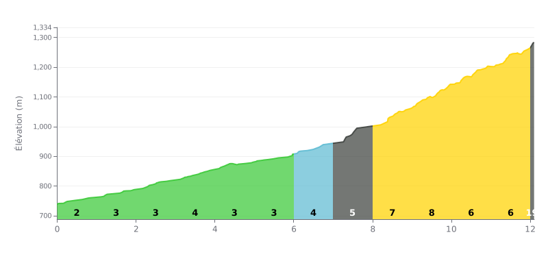
Difficulty breakdown:
This Category 1 climb has a tactical profile. The first 7 kilometers are moderate (gradients of 2% to 4%), giving you a chance to find a rhythm. Difficulty ramps up significantly in the second half, with a punchy 3 km section between 7.0 and 10.0 km (gradients of 6%, 7% and 8%). The finish stays tough at 6% over the last 2 kilometers.
How to manage the effort:
1. Pacing: Use the "easy" first part to settle into a steady aerobic effort without burning matches. Don't go out too hard.
2. Save something for the wall: Keep some energy in reserve for the steepest part (km 7 to 10). Choosing the right gearing for this section is crucial.
3. Mental toughness: The road kicks up just as the fatigue sets in. Hold a steady cadence over the final kilometers so you don't blow up.
12.1 km • 564 m D+
VAM: average climbing speed, based on elevation gain


Join thousands of cycling fans! Plan your rides, record your performance, track your progress and discover the finest climbs.
Live climb profile to pace your effort all the way to the top.

