
Bulunkou River is a climb of 30.9 kilometers (hors catégorie). Bulunkou River tops out at 3,400 m above sea level. It is located in 盖孜村 گەز, 新疆维吾尔自治区 شىنجاڭ ئۇيغۇر ئاپتونوم رايونی, 中国. The average gradient is 6.5% with a maximum of 20.7%. The climb has 1995 meters of elevation gain.
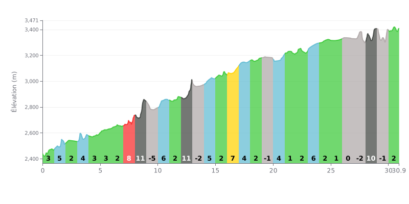
Difficulty analysis:
This beyond-category climb is 30.9 km long with 1995m of elevation gain, so it's a serious test on both counts. The main challenge is the uneven profile. The 6.5% average gradient is misleading: there are some very steep stretches, like a 13% kilometre (KM 12-13) and an 11% one (KM 8-9), and those are the ones that will decide the day. Several sections of slight descent (KM 9-10, KM 13-14, KM 19-20, KM 27-28, KM 29-30) give you valuable recovery moments.
Tips for managing your effort:
1. Ride at a steady pace and pace yourself from the start. Don't go out too hard on the easier first kilometres and blow up, so you reach the 8%, 11% and 13% sections with something left in the tank.
2. Make the most of the flat and downhill sections to recover actively (spin the legs easily) and to drink and fuel up without losing too much speed.
3. Prepare for the "walls", especially the 13% kilometre around the middle of the climb. Shift to an easier gear as you approach it to keep your cadence up.
According to the riders who have climbed this pass, the effort is rewarded with a jaw-dropping view. They describe a unique scene where white sand mountains, carved out over millennia by erosion, are mirrored in the emerald waters of the river or lake, with snow-capped peaks towering above under an intensely blue sky. This view, often compared to "paradise" or "a masterpiece of nature", is what makes the ride unforgettable.
The overall impression from the trip reports is of a scene of pure serenity. The water is described as crystal clear, and the vastness of the landscape, with its dunes, hills and snowy summits, brings a sense of calm and wonder. For many, the beauty is best taken in from a distance, as the viewpoint offers a more spectacular perspective on the whole natural setting.
Accounts also mention meeting local life, with members of the Tajik ethnic group offering traditional bread. However, some riders note that it feels very geared toward tourists, and one report mentions a down-to-earth detail that may have cooled the enthusiasm: the flatbreads were cooked after handling fuel made from dried cow dung.
30.9 km • 1995 m D+
VAM: average climbing speed, based on elevation gain


Join thousands of cycling fans! Plan your rides, record your performance, track your progress and discover the finest climbs.
Live climb profile to pace your effort all the way to the top.

