
Beklemeto Pass is a climb of 21.9 kilometers (hors catégorie). Beklemeto Pass tops out at 1,520 m above sea level. It is located in Кърнаре, Пловдив, България. The average gradient is 5.0% with a maximum of 16.4%. The climb has 1104 meters of elevation gain.
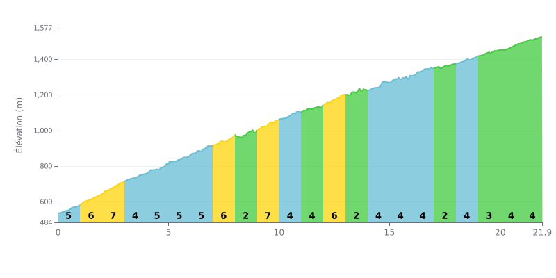
Difficulty analysis: This hors catégorie climb of 21.9 km is a sustained but steady test. Its average gradient of 5% is fairly standard, but its length and total elevation gain of 1104 m make it a demanding effort. The gradient is well spread out, with only four sections at 7% and 6% that make up the toughest stretches, while the 2% or 3% sections (KM 8-9, 13-14, 17-18, 19-20) give you brief moments to recover.
Tips for managing the effort:
1. Hold a steady rhythm. Avoid surging by pacing yourself to the 5% average gradient. Use the easier sections (2-3%) to ease off a little without stopping pedaling.
2. Anticipate the gradient changes. Kilometres 2-3 (7%) and 12-13 (6%) are the steepest. Get into a suitable gear well in advance so you don't get hit with a sudden overload.
3. Manage your effort over the distance. Length is the main challenge. Start conservatively, especially in the first third, to save something in the tank for the last 15 kilometres.
Cyclists who have climbed the Beklemeto Pass describe an intense sensory experience, where time seems to stand still in front of breathtaking views. On a clear day, you can see all the way to the Danube to the north, and take in the Balkan, Sredna Gora and Rhodope ranges. The climb snakes through dense beech forests and green landscapes, with spectacular viewpoints, especially from the Arch of Freedom monument.
The climb is defined by a winding road with plenty of switchbacks. While some riders say the tarmac is decent or has been resurfaced, others report sections in poor condition, with potholes, that demand your full attention. Traffic can be light, but cars and motorbikes do share the road.
Riders stress the unpredictable, changeable nature of the weather at altitude. It's not unusual to go from sunshine to hail, strong wind or ice on the road within a few minutes, especially in winter when some stretches can be icy.
The summit, around the Arch of Freedom, is a popular meeting point. However, some riders lament the litter left by certain visitors near the car parks and the fountain, a reminder of the importance of protecting this unique natural site. Still, the spot remains a favourite gateway to "Central Balkan" National Park and its hiking trails.
Despite the challenges, everyone agrees on the ultimate reward: the sense of freedom and the raw beauty of the scenery that stay with you long after. For many, it's a demanding but unforgettable climb, well worth the effort.
21.9 km • 1104 m D+
VAM: average climbing speed, based on elevation gain


Join thousands of cycling fans! Plan your rides, record your performance, track your progress and discover the finest climbs.
Live climb profile to pace your effort all the way to the top.

