
Avala is a climb of 4.3 kilometers (category 2). Avala tops out at 470 m above sea level. It is located in Градска општина Вождовац, Централна Србија, Србија. The average gradient is 5.1% with a maximum of 10.7%. The climb has 221 meters of elevation gain.
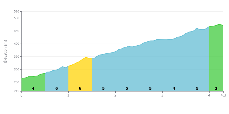
Difficulty breakdown: This Cat 2 climb is moderately hard. The average gradient of 5% over 4.3 km is steady, with a tougher opening kilometre (6% over 500m) and a very manageable finish (2% over the last 300m). It's a sustained effort, but there are no major ramps.
How to manage the effort:
1. Pace yourself from the bottom: The steepest section (6%) comes between 0.5 and 1.5 km. Don't go out too hard, or you'll rack up fatigue early.
2. Hold a steady rhythm: Most of the climb (km 1.5 to 4.0) sits at 4-5%. Find a gear that lets you keep a consistent cadence over this long stretch.
3. Save something for the final metres: The last 300m at 2% give you a chance to ease off a little and start recovering.
4.3 km • 221 m D+
VAM: average climbing speed, based on elevation gain


Join thousands of cycling fans! Plan your rides, record your performance, track your progress and discover the finest climbs.
Live climb profile to pace your effort all the way to the top.

