
Arad is a climb of 24.4 kilometers (category 1). Arad tops out at 603 m above sea level. It is located in מועצה אזורית תמר, מחוז הדרום, ישראל. The average gradient is 2.7% with a maximum of 11.1%. The climb has 658 meters of elevation gain.
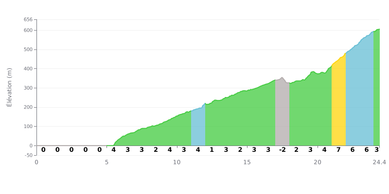
Difficulty breakdown: This 1st category climb has an atypical profile. The first 5 km are dead flat, followed by a long section (KM 5-17) at a moderate gradient (2-4%). The real difficulty is concentrated in the last 3 km (KM 21-24), with gradients hitting 6-7%, which makes it the decisive part of the climb. The short descent at KM 17 gives you a brief breather.
Pacing tips:
1. Start easy: Use the first 5 km of flat to warm up and find your rhythm without burning matches.
2. Steady rhythm: Hold a constant pace over the long section of moderate gradient (KM 5-20) to save your legs.
3. Save something for later: Keep some energy in reserve to attack the steeper finale (KM 21-24), which demands a serious effort.
24.4 km • 658 m D+
VAM: average climbing speed, based on elevation gain


Join thousands of cycling fans! Plan your rides, record your performance, track your progress and discover the finest climbs.
Live climb profile to pace your effort all the way to the top.

