
Angasolka is a climb of 10.0 kilometers (category 1). Angasolka tops out at 992 m above sea level. It is located in Култук, Иркутская область, Россия. The average gradient is 5.4% with a maximum of 11.5%. The climb has 544 meters of elevation gain.
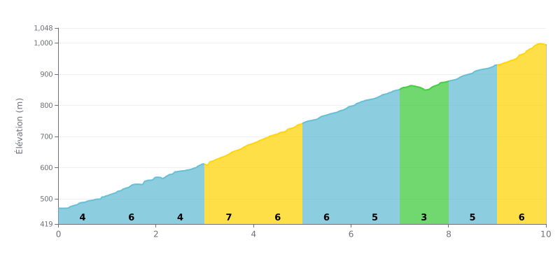
Difficulty breakdown: This Category 1 climb is a sustained, fairly steady effort. The 5.4% average gradient over 10 km is no joke. The real challenge is the string of 6-7% sections (km 1-2, 3-5, 6 and 9-10), broken up by a notable breather at km 7.0-8.0 (3%), which is crucial for recovery.
How to manage the effort:
1. Pace yourself on the steep sections: The first couple of km (1-2) and the finish (9-10) are steep (6-7%). Don't go out too hard, and save something in the tank for the final kilometres.
2. Use the km 7 breather: The 3% section is your chance to ease off a bit, shift into an easier gear and recover before the last two uphill kilometres.
3. Hold a steady rhythm: With the average gradient staying consistent, aim for a steady power output or heart rate rather than surging and fading between segments.
10.0 km • 544 m D+
VAM: average climbing speed, based on elevation gain


Join thousands of cycling fans! Plan your rides, record your performance, track your progress and discover the finest climbs.
Live climb profile to pace your effort all the way to the top.

