
Ancient Thera is a climb of 2.9 kilometers (category 1). Ancient Thera tops out at 260 m above sea level. It is located in Δημοτική Ενότητα Θήρας, Αποκεντρωμένη Διοίκηση Αιγαίου, Ελλάς. The average gradient is 9.6% with a maximum of 19.4%. The climb has 279 meters of elevation gain.
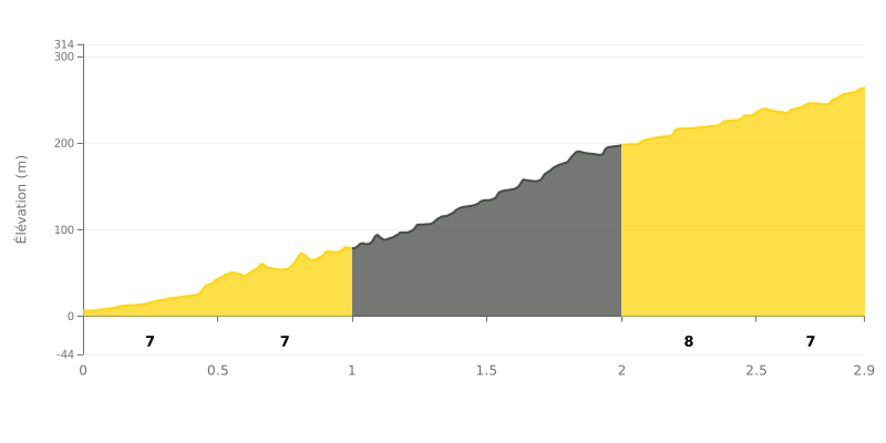
Difficulty analysis: This short (2.9 km) but intense climb has an average gradient of a brutal 9.6%. Its difficulty lies in an extremely steep central section, with two consecutive kilometres at 11% and 13%, where most of the elevation gain is packed in. The 1st category rating is justified by this combination of steepness and demanding profile.
Tips for managing the effort:
1. Pacing the middle section: Start at a measured pace over the first 7% to save your legs. Be ready for the sudden jump in gradient between km 1 and km 2 (11-13%) and adjust your effort so you don't blow up.
2. Choosing the right gearing: The steepness of the middle pitches calls for a fairly generous gear range. Pick a gearing that lets you hold a decent cadence (at least 70-75 rpm) on the 13% ramps.
3. Enjoying the easier finish: The last 900 metres at 7-8% offer some relief. Use this stretch to recover a bit and gradually pick up the pace if you have anything left in the tank.
Cyclists who have climbed to Ancient Thera describe a demanding climb rewarded by breathtaking scenery. The winding road, with its many tight switchbacks and significant elevation gain, is a real physical challenge. The road surface is decent, but the frequent lack of guardrails and the traffic (cars, quad bikes) on this narrow road call for constant vigilance.
The effort is more than repaid by a unique panoramic view over the island. From the top of the mountain, the 360-degree panorama stretches over the beaches of Kamari and Perissa, the rest of Santorini and, on clear days, all the way to Crete. Riders often mention the thrilling feeling of looking down on the island and watching planes land below.
At the summit, exploring the majestic ancient ruins makes for a well-earned cultural break. Cyclists enjoy wandering among the remains of this thousand-year-old city, which give deep historical meaning to their effort. The size of the site, with its theatre, temples and streets, impresses visitors.
To make this climb a success, your gear is crucial: bring plenty of water, as there is no water point at the top, and protect yourself from the sun and wind, which can be intense. Many riders also recommend checking the opening hours of the archaeological site in advance so you don't get caught out after all that effort.
2.9 km • 279 m D+
VAM: average climbing speed, based on elevation gain


Join thousands of cycling fans! Plan your rides, record your performance, track your progress and discover the finest climbs.
Live climb profile to pace your effort all the way to the top.

